IMAGES TAKEN NEAR TO
Greenlees Way, GLASGOW, G72 8YG
Introduction
This page details the photographs taken nearby to Greenlees Way, G72 8YG by members of the Geograph project.
The Geograph project started in 2005 with the aim of publishing, organising and preserving representative images for every square kilometre of Great Britain, Ireland and the Isle of Man.

There are currently over 7.5m images from over14,400 individuals and you can help contribute to the project by visiting https://www.geograph.org.uk
Image Map
Images are licensed for reuse under creativecommons.org/licenses/by-sa/2.0
Notes
- Clicking on the map will re-center to the selected point.
- The higher the marker number, the further away the image location is from the centre of the postcode.
Image Listing (4 Images Found)
Images are licensed for reuse under creativecommons.org/licenses/by-sa/2.0
Image
Details
Distance
1

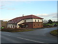
Kirkhill Golf Club - Clubhouse
Par 70 golf course just south of Cambuslang.
The current clubhouse was built in 2004 at a cost of £1.4m.
Image: © G Laird
Taken: 29 Oct 2013
0.07 miles
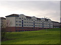
4
Lorne Terrace, Whitlawburn
From Western Road.
Image: © Stephen Sweeney
Taken: 1 Apr 2009
0.20 miles