IMAGES TAKEN NEAR TO
Loudon Grove, GLASGOW, G72 8XS
Introduction
This page details the photographs taken nearby to Loudon Grove, G72 8XS by members of the Geograph project.
The Geograph project started in 2005 with the aim of publishing, organising and preserving representative images for every square kilometre of Great Britain, Ireland and the Isle of Man.

There are currently over 7.5m images from over14,400 individuals and you can help contribute to the project by visiting https://www.geograph.org.uk
Image Map
Images are licensed for reuse under creativecommons.org/licenses/by-sa/2.0
Notes
- Clicking on the map will re-center to the selected point.
- The higher the marker number, the further away the image location is from the centre of the postcode.
Image Listing (6 Images Found)
Images are licensed for reuse under creativecommons.org/licenses/by-sa/2.0
Image
Details
Distance
1

Memorial cairn
The cairn commemorates the soldiers who used the path to Newton Station from the Army base at Dechmont. After training this was their route to the two great wars of the 20th century.
Image: © Richard Webb
Taken: 4 Jun 2012
0.08 miles
2

Small Shopping Centre just outside Halfway
At the junction of Hamilton Road and Hallside Boulevard.
Image: © G Laird
Taken: 17 Jan 2010
0.11 miles
3
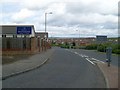
Road into Drumsagard
A very Scottish name for this housing area east of Cambuslang.
Image: © Stephen Sweeney
Taken: 17 Jun 2009
0.15 miles
4
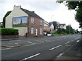
Billboard on side of house
I wonder if the owners receive any fees?! On Hamilton Road, Flemington.
Image: © Stephen Sweeney
Taken: 17 Jun 2009
0.17 miles
5

Church on Hamilton Road
The banner says "Halfway to Heaven" - anything to do with the nearby village of Halfway?!
Image: © Stephen Sweeney
Taken: 17 Jun 2009
0.24 miles
6
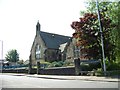
"Halfway to Heaven" says the banner on this church just outside the village of Halfway
Image: © Elliott Simpson
Taken: 24 May 2012
0.24 miles