IMAGES TAKEN NEAR TO
Lightburn Road, GLASGOW, G72 8UA
Introduction
This page details the photographs taken nearby to Lightburn Road, G72 8UA by members of the Geograph project.
The Geograph project started in 2005 with the aim of publishing, organising and preserving representative images for every square kilometre of Great Britain, Ireland and the Isle of Man.

There are currently over 7.5m images from over14,400 individuals and you can help contribute to the project by visiting https://www.geograph.org.uk
Image Map
Images are licensed for reuse under creativecommons.org/licenses/by-sa/2.0
Notes
- Clicking on the map will re-center to the selected point.
- The higher the marker number, the further away the image location is from the centre of the postcode.
Image Listing (11 Images Found)
Images are licensed for reuse under creativecommons.org/licenses/by-sa/2.0
Image
Details
Distance
1

The Sun Inn, Halfway
Pub in the village of Halfway, Lanarkshire.
Image: © Stephen Sweeney
Taken: 17 Jun 2009
0.05 miles
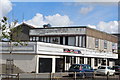
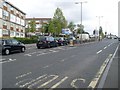
3
Hamilton Road, Halfway
Main row of shops in the village.
Image: © Stephen Sweeney
Taken: 17 Jun 2009
0.09 miles
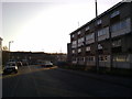
4
Flats in Halfway
At the corner of Hamilton Road and Mill Road.
Image: © Stephen Sweeney
Taken: 17 Jun 2009
0.10 miles
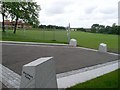
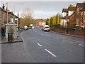
5
Mill Road, approaching Hamilton Road
Image: © Elliott Simpson
Taken: 26 Jan 2017
0.12 miles
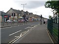
6
Hamilton Road at Mill Road
In Halfway.
Image: © Stephen Sweeney
Taken: 17 Jun 2009
0.12 miles
8
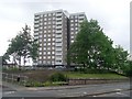
Logan Tower
Highrise flats in Flemington.
Image: © Stephen Sweeney
Taken: 17 Jun 2009
0.20 miles
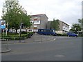
9
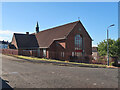
St Cadoc's church, Halfway, Cambuslang
A brick built church in a housing estate. The church opened in 1955.
Image: © wrobison
Taken: 10 Jul 2022
0.21 miles
10
Hamilton Road, Halfway
Looking in the direction of Cambuslang.
Image: © G Laird
Taken: 17 Jan 2010
0.23 miles