IMAGES TAKEN NEAR TO
Rosebank Drive, GLASGOW, G72 8TE
Introduction
This page details the photographs taken nearby to Rosebank Drive, G72 8TE by members of the Geograph project.
The Geograph project started in 2005 with the aim of publishing, organising and preserving representative images for every square kilometre of Great Britain, Ireland and the Isle of Man.

There are currently over 7.5m images from over14,400 individuals and you can help contribute to the project by visiting https://www.geograph.org.uk
Image Map
Images are licensed for reuse under creativecommons.org/licenses/by-sa/2.0
Notes
- Clicking on the map will re-center to the selected point.
- The higher the marker number, the further away the image location is from the centre of the postcode.
Image Listing (8 Images Found)
Images are licensed for reuse under creativecommons.org/licenses/by-sa/2.0
Image
Details
Distance
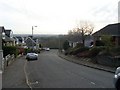
1
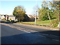
Passing through Halfway at Cambuslang
Grass, trees and houses in the 'suburb' of the Lanarkshire town.
Image: © James Denham
Taken: 4 Nov 2013
0.14 miles
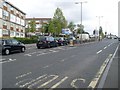
2
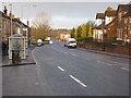
Hamilton Road, Halfway
Looking in the direction of Cambuslang.
Image: © G Laird
Taken: 17 Jan 2010
0.16 miles
3
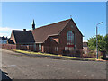
St Cadoc's church, Halfway, Cambuslang
A brick built church in a housing estate. The church opened in 1955.
Image: © wrobison
Taken: 10 Jul 2022
0.16 miles
5
Howieshill Road
Steep residential road in Cambuslang.
Image: © Stephen Sweeney
Taken: 1 Apr 2009
0.21 miles
6
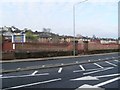
Site of former South Lanarkshire College
Now relocated to East Kilbride.
Image: © Stephen Sweeney
Taken: 1 Apr 2009
0.23 miles
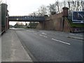
7
Hamilton Road at Mill Road
In Halfway.
Image: © Stephen Sweeney
Taken: 17 Jun 2009
0.25 miles
8
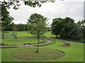
Cambuslang Park
View in from Cairns Road.
Image: © Richard Webb
Taken: 4 Jun 2012
0.25 miles