IMAGES TAKEN NEAR TO
Wallace Wynd, GLASGOW, G72 8SE
Introduction
This page details the photographs taken nearby to Wallace Wynd, G72 8SE by members of the Geograph project.
The Geograph project started in 2005 with the aim of publishing, organising and preserving representative images for every square kilometre of Great Britain, Ireland and the Isle of Man.

There are currently over 7.5m images from over14,400 individuals and you can help contribute to the project by visiting https://www.geograph.org.uk
Image Map
Images are licensed for reuse under creativecommons.org/licenses/by-sa/2.0
Notes
- Clicking on the map will re-center to the selected point.
- The higher the marker number, the further away the image location is from the centre of the postcode.
Image Listing (2 Images Found)
Images are licensed for reuse under creativecommons.org/licenses/by-sa/2.0
Image
Details
Distance
1
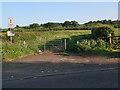
Turnlaw Road at East Greenlees Road
The road is closed to all vehicles except for farm vehicles and is used by walkers and cyclists.
Image: © wrobison
Taken: 3 Jun 2023
0.19 miles
2
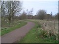
Holmhills Wood Community Park
In Cambuslang.
Image: © Stephen Sweeney
Taken: 1 Apr 2009
0.24 miles