IMAGES TAKEN NEAR TO
Cairns Road, GLASGOW, G72 8PZ
Introduction
This page details the photographs taken nearby to Cairns Road, G72 8PZ by members of the Geograph project.
The Geograph project started in 2005 with the aim of publishing, organising and preserving representative images for every square kilometre of Great Britain, Ireland and the Isle of Man.

There are currently over 7.5m images from over14,400 individuals and you can help contribute to the project by visiting https://www.geograph.org.uk
Image Map
Images are licensed for reuse under creativecommons.org/licenses/by-sa/2.0
Notes
- Clicking on the map will re-center to the selected point.
- The higher the marker number, the further away the image location is from the centre of the postcode.
Image Listing (4 Images Found)
Images are licensed for reuse under creativecommons.org/licenses/by-sa/2.0
Image
Details
Distance
1
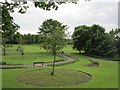
Cambuslang Park
View in from Cairns Road.
Image: © Richard Webb
Taken: 4 Jun 2012
0.11 miles
2
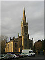
Church in Cambuslang
Cambuslang Old Parish Church. Adjacent to Vicarland Road
Image: © Iain Thompson
Taken: 27 Dec 2005
0.18 miles
3
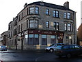
Carrigans Bar, Cambuslang
Corner of Glebe Place and Cadoc Street, Cambuslang
Image: © Ian Paterson
Taken: 3 Mar 2007
0.20 miles
4
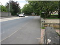
Greenlees Road, Cambuslang, looking East
Looking roughly East along a section of Greenlees Road, Cambuslang. The road leading off to the right is Mansefield Avenue.
Image: © Andrew Reid
Taken: 1 Sep 2011
0.22 miles