IMAGES TAKEN NEAR TO
Borgie Crescent, GLASGOW, G72 8JY
Introduction
This page details the photographs taken nearby to Borgie Crescent, G72 8JY by members of the Geograph project.
The Geograph project started in 2005 with the aim of publishing, organising and preserving representative images for every square kilometre of Great Britain, Ireland and the Isle of Man.

There are currently over 7.5m images from over14,400 individuals and you can help contribute to the project by visiting https://www.geograph.org.uk
Image Map
Images are licensed for reuse under creativecommons.org/licenses/by-sa/2.0
Notes
- Clicking on the map will re-center to the selected point.
- The higher the marker number, the further away the image location is from the centre of the postcode.
Image Listing (39 Images Found)
Images are licensed for reuse under creativecommons.org/licenses/by-sa/2.0
Image
Details
Distance
1
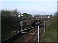
Railway passes beneath Croft Road
In Cambuslang.
Image: © Stephen Sweeney
Taken: 1 Apr 2009
0.10 miles
2
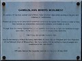
Plaque on the Cambuslang Miners' Monument
See Image for the actual monument
Image: © Elliott Simpson
Taken: 24 May 2012
0.11 miles
3
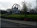
Cambuslang Miners' Monument
Dedicated to those who worked - and in some cases died - in the local mines.
Image: © Stephen Sweeney
Taken: 1 Apr 2009
0.11 miles
5
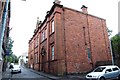
Masonic Lodge, Cambuslang
Lodge Cambuslang Royal Arch No.114 and Lodge Kirkhill No.1230, Cambuslang, Glasgow.
Image: © Jim Campbell
Taken: 4 Aug 2007
0.12 miles
8
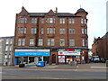
Post Office and shops on Main Street (A724), Cambuslang
Image: © JThomas
Taken: 16 Sep 2021
0.14 miles