IMAGES TAKEN NEAR TO
Aspen Place, GLASGOW, G72 7ZE
Introduction
This page details the photographs taken nearby to Aspen Place, G72 7ZE by members of the Geograph project.
The Geograph project started in 2005 with the aim of publishing, organising and preserving representative images for every square kilometre of Great Britain, Ireland and the Isle of Man.

There are currently over 7.5m images from over14,400 individuals and you can help contribute to the project by visiting https://www.geograph.org.uk
Image Map
Images are licensed for reuse under creativecommons.org/licenses/by-sa/2.0
Notes
- Clicking on the map will re-center to the selected point.
- The higher the marker number, the further away the image location is from the centre of the postcode.
Image Listing (5 Images Found)
Images are licensed for reuse under creativecommons.org/licenses/by-sa/2.0
Image
Details
Distance
1
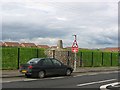
Hallside
New housing on a brownfield site. The triangulation pillar was inside the grounds of Hallside Primary School. Since the photograph was taken, the pillar has been removed and the site is used as a football pitch.
Image: © Richard Webb
Taken: 27 Apr 2004
0.04 miles
2
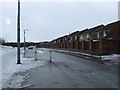
Newton Station Road
Traffic calming measures in the foreground, outside Newton railway station.
Image: © Thomas Nugent
Taken: 30 Dec 2009
0.14 miles
3
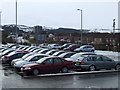
Park & Ride at Newton
Looking from the station towards Newton Station Road.
Image: © Thomas Nugent
Taken: 30 Dec 2009
0.21 miles
4
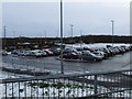
Park & Ride at Newton
The Park & Ride car park beside Newton railway station.
Image: © Thomas Nugent
Taken: 30 Dec 2009
0.24 miles
5
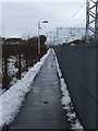
Path at Newton railway station
This long, narrow path runs parallel with the railway line until Mill Road.
Image: © Thomas Nugent
Taken: 30 Dec 2009
0.25 miles