IMAGES TAKEN NEAR TO
Carron Court, GLASGOW, G72 7YW
Introduction
This page details the photographs taken nearby to Carron Court, G72 7YW by members of the Geograph project.
The Geograph project started in 2005 with the aim of publishing, organising and preserving representative images for every square kilometre of Great Britain, Ireland and the Isle of Man.

There are currently over 7.5m images from over14,400 individuals and you can help contribute to the project by visiting https://www.geograph.org.uk
Image Map
Images are licensed for reuse under creativecommons.org/licenses/by-sa/2.0
Notes
- Clicking on the map will re-center to the selected point.
- The higher the marker number, the further away the image location is from the centre of the postcode.
Image Listing (5 Images Found)
Images are licensed for reuse under creativecommons.org/licenses/by-sa/2.0
Image
Details
Distance
1
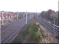
Railway Junction west of Newton Station
Both lines here lead to Glasgow Central in the opposite direction of the photograph. The line on the left is the main south railway line while the line on the right is a local line via Kings Park.
Image: © G Laird
Taken: 17 Jan 2010
0.15 miles
3
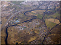
Road, rail and river from the air
The M73 and M74 motorways, West Coast Main Line railway and the River Clyde are prominent. Newton station on the Argyle Lins is in the lower right corner. Broomhouse is on the left, Uddingston is in the distance.
Image: © Thomas Nugent
Taken: 19 Mar 2018
0.24 miles
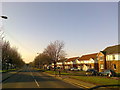
5
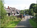
Northbank Avenue
View along the cycle path (National Cycle Route 75) towards the end of Northbank Avenue and some wooden houses.
Image: © Richard Webb
Taken: 25 Jul 2008
0.25 miles