IMAGES TAKEN NEAR TO
Redlawood Road, GLASGOW, G72 7UZ
Introduction
This page details the photographs taken nearby to Redlawood Road, G72 7UZ by members of the Geograph project.
The Geograph project started in 2005 with the aim of publishing, organising and preserving representative images for every square kilometre of Great Britain, Ireland and the Isle of Man.

There are currently over 7.5m images from over14,400 individuals and you can help contribute to the project by visiting https://www.geograph.org.uk
Image Map
Images are licensed for reuse under creativecommons.org/licenses/by-sa/2.0
Notes
- Clicking on the map will re-center to the selected point.
- The higher the marker number, the further away the image location is from the centre of the postcode.
Image Listing (14 Images Found)
Images are licensed for reuse under creativecommons.org/licenses/by-sa/2.0
Image
Details
Distance
1
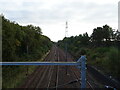
Railway junction, Newton
From the bridge on Westburn Road.
Image: © JThomas
Taken: 16 Sep 2021
0.04 miles
2
Modern flats, Newton
Modern blocks of flats in Newton. Photo taken from waste ground which was the previous site of a primary school
Image: © Graham Crowe
Taken: 1 Mar 2016
0.06 miles
3
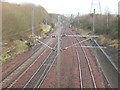
Railway Near Newton
Newton to Uddingston track at Newton
Image: © Iain Thompson
Taken: 14 Jan 2006
0.06 miles
4

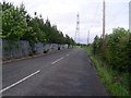
Grazing and pylon beside railway, Newton
Off Westburn Road.
Image: © JThomas
Taken: 16 Sep 2021
0.07 miles
5
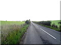
Sharp bend on road near Newton Village
Heading away from the village.
Image: © Stephen Sweeney
Taken: 17 Jun 2009
0.11 miles
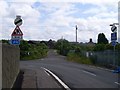
6
Country road near Newton
The fence separates the road from the adjacent railway line, as seen on the OS map.
Image: © Stephen Sweeney
Taken: 17 Jun 2009
0.12 miles
7

St Charles' Primary School, Newton
One of two Primary schools in the Newton Village development.
Image: © wrobison
Taken: 10 Jul 2022
0.14 miles
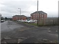
8
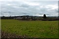
Hallside Newhouse farm (Derelict)
Another old farm surrounded by neglected fields.
Image: © Robert Murray
Taken: 25 Feb 2016
0.14 miles
9
Westburn Road
National Cycle Route 75 towards the B758.
Image: © JThomas
Taken: 16 Sep 2021
0.15 miles
10
![Hallside Newhouse farm (Derelict) [2]](https://s1.geograph.org.uk/geophotos/04/87/57/4875741_400c61e7_120x120.jpg)
Hallside Newhouse farm (Derelict) [2]
Close up of derelict buildings.
Image: © Robert Murray
Taken: 25 Feb 2016
0.15 miles