IMAGES TAKEN NEAR TO
Westfarm Grove, GLASGOW, G72 7RN
Introduction
This page details the photographs taken nearby to Westfarm Grove, G72 7RN by members of the Geograph project.
The Geograph project started in 2005 with the aim of publishing, organising and preserving representative images for every square kilometre of Great Britain, Ireland and the Isle of Man.

There are currently over 7.5m images from over14,400 individuals and you can help contribute to the project by visiting https://www.geograph.org.uk
Image Map
Images are licensed for reuse under creativecommons.org/licenses/by-sa/2.0
Notes
- Clicking on the map will re-center to the selected point.
- The higher the marker number, the further away the image location is from the centre of the postcode.
Image Listing (11 Images Found)
Images are licensed for reuse under creativecommons.org/licenses/by-sa/2.0
Image
Details
Distance
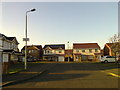
2
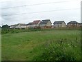
New houses, Newton Bridge
The houses are newly built - this was a building site the last time that I passed this way. The address of the houses is West Farm Grove.
Image: © Richard Webb
Taken: 9 Jun 2012
0.03 miles
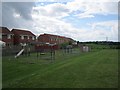
3
Playpark, Westburn Village
In the area of Newton Bridge.
Image: © Stephen Sweeney
Taken: 17 Jun 2009
0.05 miles
4
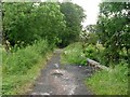
Path behind Westburn Village
As it crosses Newton Burn.
Image: © Stephen Sweeney
Taken: 17 Jun 2009
0.08 miles
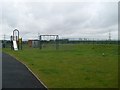
5
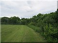
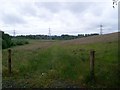
Playing field off Newton Avenue
A recreational area for the new houses which have been built off Newton Avenue in the preceding few years. The avenue runs as an old road through the woods on the right.
Image: © Richard Webb
Taken: 9 Jun 2012
0.09 miles
6
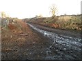
Tree Stumps near Newton Burn
A muddy scene following the felling of trees lining the pathway from Westburn to the site of Newton House
Image: © Graham Crowe
Taken: 22 Nov 2015
0.14 miles
7
Westburn Village
From the Clyde Walkway.
Image: © Stephen Sweeney
Taken: 17 Jun 2009
0.16 miles
8
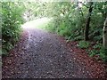
Well-shaded path
Behind Westburn Village, near Glasgow.
Image: © Stephen Sweeney
Taken: 17 Jun 2009
0.19 miles
9
Path through field north of Westburn Village
Image: © Stephen Sweeney
Taken: 17 Jun 2009
0.21 miles
10
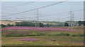
Pylonland - the magenta season
Powerlines converge on a substation near Newton Bridge. Between the cyclepath and River Clyde is a large area of land which is no longer in agricultural use and colonised by rosebay willow herb.
Image: © Richard Webb
Taken: 25 Jul 2008
0.22 miles