IMAGES TAKEN NEAR TO
Birch Grove, GLASGOW, G72 7LW
Introduction
This page details the photographs taken nearby to Birch Grove, G72 7LW by members of the Geograph project.
The Geograph project started in 2005 with the aim of publishing, organising and preserving representative images for every square kilometre of Great Britain, Ireland and the Isle of Man.

There are currently over 7.5m images from over14,400 individuals and you can help contribute to the project by visiting https://www.geograph.org.uk
Image Map
Images are licensed for reuse under creativecommons.org/licenses/by-sa/2.0
Notes
- Clicking on the map will re-center to the selected point.
- The higher the marker number, the further away the image location is from the centre of the postcode.
Image Listing (7 Images Found)
Images are licensed for reuse under creativecommons.org/licenses/by-sa/2.0
Image
Details
Distance

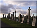
2
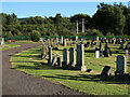
Westburn Cemetery, Cambuslang
The cemetery was opened in 1889.
Image: © wrobison
Taken: 10 Jul 2022
0.13 miles

6
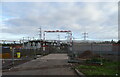
Electricity sub station off Westburn Road, Cambuslang
Image: © JThomas
Taken: 16 Sep 2021
0.22 miles
7
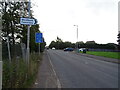
Westburn Road, Cambuslang
Junction with Old Mill Road.
Image: © JThomas
Taken: 16 Sep 2021
0.23 miles