IMAGES TAKEN NEAR TO
Sycamore Way, GLASGOW, G72 7FT
Introduction
This page details the photographs taken nearby to Sycamore Way, G72 7FT by members of the Geograph project.
The Geograph project started in 2005 with the aim of publishing, organising and preserving representative images for every square kilometre of Great Britain, Ireland and the Isle of Man.

There are currently over 7.5m images from over14,400 individuals and you can help contribute to the project by visiting https://www.geograph.org.uk
Image Map
Images are licensed for reuse under creativecommons.org/licenses/by-sa/2.0
Notes
- Clicking on the map will re-center to the selected point.
- The higher the marker number, the further away the image location is from the centre of the postcode.
Image Listing (4 Images Found)
Images are licensed for reuse under creativecommons.org/licenses/by-sa/2.0
Image
Details
Distance
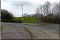
3

Footpath in Drumsargad
Drumsagard Village is a new construction established after the closure of the nearby Hallside Steelworks in 1979 and is built around the site of Drumsagard Castle. The footpath is separated by bushes from Hallside Boulevard, the main road through the development.
Image: © wrobison
Taken: 18 Jun 2022
0.17 miles
4
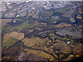
Calderglen from the air
Calderglen is in the foreground. The River Clyde and Bothwell are in the background. Bothwell Castle is to the right of centre.
Image: © Thomas Nugent
Taken: 19 Mar 2018
0.23 miles