IMAGES TAKEN NEAR TO
Bridge Street, GLASGOW, G72 7EA
Introduction
This page details the photographs taken nearby to Bridge Street, G72 7EA by members of the Geograph project.
The Geograph project started in 2005 with the aim of publishing, organising and preserving representative images for every square kilometre of Great Britain, Ireland and the Isle of Man.

There are currently over 7.5m images from over14,400 individuals and you can help contribute to the project by visiting https://www.geograph.org.uk
Image Map
Images are licensed for reuse under creativecommons.org/licenses/by-sa/2.0
Notes
- Clicking on the map will re-center to the selected point.
- The higher the marker number, the further away the image location is from the centre of the postcode.
Image Listing (43 Images Found)
Images are licensed for reuse under creativecommons.org/licenses/by-sa/2.0
Image
Details
Distance
1
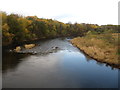
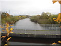
The River Clyde
Heading downstream at Cambuslang.
Image: © James Denham
Taken: 16 Nov 2013
0.05 miles
2
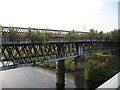
On Cambuslang Bridge
This bridge carried the A763 across the Clyde until the construction of the Clydeford Bridge upstream in 1976. The carriageway markings can still be seen. It is now usable as a footbridge. The picture looks towards the south bank of the Clyde from about halfway along.
Image: © Alec MacKinnon
Taken: 29 Oct 2020
0.06 miles
3
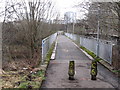
Cambuslang Bridge
Disused bridge over the Clyde, now sprouting saplings. View from the bridge carrying the Clyde Walkway.
Image: © Richard Webb
Taken: 25 Jul 2008
0.06 miles
4
Cambuslang Bridge
Litter and an air of neglect spoils what should be a place to linger and enjoy views of the River Clyde.
Image: © Frank Smith
Taken: 9 Feb 2017
0.07 miles
5
River Clyde at Cambuslang
Looking upstream over the footbridge. Taken from the old Cambuslang Bridge, now used as a footbridge too.
Image: © James Denham
Taken: 16 Nov 2013
0.10 miles
6
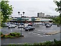
Bridge Street, Cambuslang
The car park on the left is on the site of the Cambuslang Dye Works, see https://maps.nls.uk/geo/explore/#zoom=17.0&lat=55.82159&lon=-4.17311&layers=168&b=1&o=100
Image: © wrobison
Taken: 7 Sep 2024
0.11 miles
7
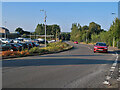
Morrisons, Cambuslang
Just off of Bridge Street.
Image: © Stephen Sweeney
Taken: 17 Jun 2009
0.12 miles
8
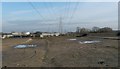
Cambuslang Industrial Estate during development
The undeveloped area is the one that is shown in front of (that is, to the south of) the building in Image Both pictures were taken on the same excursion in 2006. The view is from the cycle path, and the power lines allow the viewpoint to be determined fairly accurately.
Fourteen years later, when this picture was submitted, the cleared ground shown here had long since been occupied by additional buildings of the industrial estate.
Image: © Lairich Rig
Taken: 3 Feb 2006
0.17 miles
9
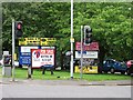
Hoardings, Cambuslang
Advertising where Bridge Street meets Glasgow Road and Main Street opposite the railway station.
Image: © Richard Webb
Taken: 29 Jun 2011
0.17 miles
10
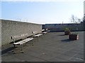
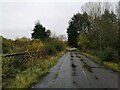
Park benches
By Glasgow Road in Cambuslang.
Image: © Stephen Sweeney
Taken: 1 Apr 2009
0.18 miles