IMAGES TAKEN NEAR TO
Glenburn Avenue, GLASGOW, G72 7AP
Introduction
This page details the photographs taken nearby to Glenburn Avenue, G72 7AP by members of the Geograph project.
The Geograph project started in 2005 with the aim of publishing, organising and preserving representative images for every square kilometre of Great Britain, Ireland and the Isle of Man.

There are currently over 7.5m images from over14,400 individuals and you can help contribute to the project by visiting https://www.geograph.org.uk
Image Map
Images are licensed for reuse under creativecommons.org/licenses/by-sa/2.0
Notes
- Clicking on the map will re-center to the selected point.
- The higher the marker number, the further away the image location is from the centre of the postcode.
Image Listing (7 Images Found)
Images are licensed for reuse under creativecommons.org/licenses/by-sa/2.0
Image
Details
Distance
1
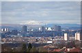
A view across Glasgow
A view across Glasgow taken from Cambuslang. The snow covered mountain in distance is Ben Lomond.
Image: © Paul McIlroy
Taken: 16 Mar 2008
0.16 miles
3
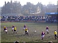
Somervell Park, Cambuslang. Football ground
Somervell Park, home of Cambuslang Rangers FC
Image: © paul c
Taken: 22 Feb 2003
0.19 miles
4

Cambuslang from the air
Trinity High School and Cathkin High School can be seen in the foreground, with the River Clyde and M74 motorway in the background.
Image: © Thomas Nugent
Taken: 1 May 2017
0.19 miles
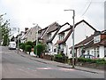
6
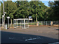
Bus stop on Duke's Road at Quarryfield Park
The park is on the site of Wellshot Quarry.
Image: © wrobison
Taken: 7 Sep 2024
0.23 miles
7
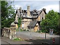
Cambus Court Hotel
A closed and later "nedded" hotel. The closed hotel was set on fire on a Saturday night, 22nd January 2011.
Image: © Richard Webb
Taken: 29 Jun 2011
0.24 miles