IMAGES TAKEN NEAR TO
Shepherds Way, GLASGOW, G72 6WS
Introduction
This page details the photographs taken nearby to Shepherds Way, G72 6WS by members of the Geograph project.
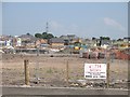
The Geograph project started in 2005 with the aim of publishing, organising and preserving representative images for every square kilometre of Great Britain, Ireland and the Isle of Man.

There are currently over 7.5m images from over14,400 individuals and you can help contribute to the project by visiting https://www.geograph.org.uk
Image Map
Images are licensed for reuse under creativecommons.org/licenses/by-sa/2.0
Notes
- Clicking on the map will re-center to the selected point.
- The higher the marker number, the further away the image location is from the centre of the postcode.
Image Listing (45 Images Found)
Images are licensed for reuse under creativecommons.org/licenses/by-sa/2.0
Image
Details
Distance
2
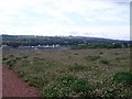
Newton Farm
Residential development with a handy nearby railway station.
Image: © Richard Webb
Taken: 25 Jul 2008
0.08 miles

4
Looking to construction work at Newton Farm
New houses being built by Westburn Road.
Image: © Stephen Sweeney
Taken: 17 Jun 2009
0.10 miles
5
Newton Farm
Multi company housing development by Newton railway station.
Image: © Thomas Nugent
Taken: 30 Dec 2009
0.11 miles
7
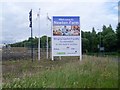
Sign at Newton Farm
Development ongoing at the site near Newton station.
Image: © Stephen Sweeney
Taken: 17 Jun 2009
0.11 miles
8
Westburn Road
By Newton railway station.
Image: © Thomas Nugent
Taken: 30 Dec 2009
0.13 miles
9
Westburn Road
National Cycle Route 75 heading east near Newton Station.
Image: © JThomas
Taken: 16 Sep 2021
0.13 miles
10
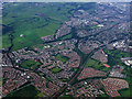
Newton and Cambuslang from the air
Newton railway station is at the bottom of the photo.
Image: © Thomas Nugent
Taken: 9 Jun 2012
0.13 miles