IMAGES TAKEN NEAR TO
Collie Wynd, GLASGOW, G72 6WF
Introduction
This page details the photographs taken nearby to Collie Wynd, G72 6WF by members of the Geograph project.
The Geograph project started in 2005 with the aim of publishing, organising and preserving representative images for every square kilometre of Great Britain, Ireland and the Isle of Man.

There are currently over 7.5m images from over14,400 individuals and you can help contribute to the project by visiting https://www.geograph.org.uk
Image Map
Images are licensed for reuse under creativecommons.org/licenses/by-sa/2.0
Notes
- Clicking on the map will re-center to the selected point.
- The higher the marker number, the further away the image location is from the centre of the postcode.
Image Listing (10 Images Found)
Images are licensed for reuse under creativecommons.org/licenses/by-sa/2.0
Image
Details
Distance
1
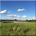
Newton Farm housing
View from a small hill looking over a modern housing development in lands previously belonging to Newton Farm
Image: © Graham Crowe
Taken: 13 Jun 2015
0.08 miles
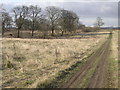
3

Path near Newton Farm
The new housing in the area can be seen in the background.
Image: © Stephen Sweeney
Taken: 17 Jun 2009
0.16 miles
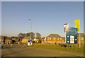
4
Westburn Wasteland
Large area of waste ground between Westburn and Newton Farm
Image: © Chris Upson
Taken: 17 Mar 2006
0.16 miles
5
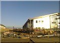
New school being built at Newton Farm
Image: © Elliott Simpson
Taken: 26 Jan 2017
0.17 miles
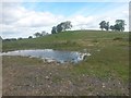
7
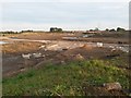
Cleared land, Newton
A large expanse of farmland which was cleared in advance of development into housing. The beginnings of the road and drainage systems can be seen in the foreground
Image: © Graham Crowe
Taken: 27 Sep 2015
0.18 miles
8
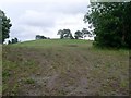
Hill behind Westburn Village
From the path leading on from Newton Avenue.
Image: © Stephen Sweeney
Taken: 17 Jun 2009
0.19 miles
9
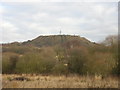
Westburn-Newton hill from east
View looking west towards a small hill with copses separating the districts of Westburn and Newton. The flatter land in the foreground will be converted into housing and a main road in the coming years
Image: © Graham Crowe
Taken: 16 May 2015
0.20 miles
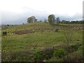
10
Westburn-Newton hill from south
View looking north to a small hill separating the districts of Westburn and Newton. The land in the foreground is scheduled to become a housing and shopping area in the coming years
Image: © Graham Crowe
Taken: 30 May 2015
0.21 miles