IMAGES TAKEN NEAR TO
Harvester Avenue, GLASGOW, G72 6AA
Introduction
This page details the photographs taken nearby to Harvester Avenue, G72 6AA by members of the Geograph project.
The Geograph project started in 2005 with the aim of publishing, organising and preserving representative images for every square kilometre of Great Britain, Ireland and the Isle of Man.

There are currently over 7.5m images from over14,400 individuals and you can help contribute to the project by visiting https://www.geograph.org.uk
Image Map
Images are licensed for reuse under creativecommons.org/licenses/by-sa/2.0
Notes
- Clicking on the map will re-center to the selected point.
- The higher the marker number, the further away the image location is from the centre of the postcode.
Image Listing (8 Images Found)
Images are licensed for reuse under creativecommons.org/licenses/by-sa/2.0
Image
Details
Distance
1
New school being built at Newton Farm
Image: © Elliott Simpson
Taken: 26 Jan 2017
0.04 miles
2
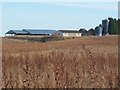
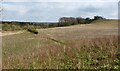
Newton Farm, seen from the Clyde Walkway
This stretch of the Clyde Walkway passes through overgrown fields, and closely follows the course of the river.
Image: © Lairich Rig
Taken: 10 Feb 2006
0.10 miles
3
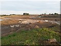
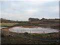
Cleared land, Newton
A large expanse of farmland which was cleared in advance of development into housing. The beginnings of the road and drainage systems can be seen in the foreground
Image: © Graham Crowe
Taken: 27 Sep 2015
0.11 miles
4
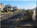
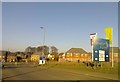
Harvester Avenue, Newton
In the Newton Fields part of the Newton Village development. With over 2,000 new homes, two new primary schools, large areas of community open space and a retail area being built, it is going to be a large village.
Image: © wrobison
Taken: 10 Jul 2022
0.18 miles
5

Path near Newton Farm
The new housing in the area can be seen in the background.
Image: © Stephen Sweeney
Taken: 17 Jun 2009
0.20 miles
6
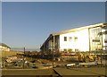
Building Site
A large area between Westburn and the River Clyde is currently being developed for housing.
Image: © Frank Smith
Taken: 27 Jan 2017
0.21 miles
7
Path from Newton Farm
In places, the path is lined by bushes; it is shown as a boundary on the map.
As the photo (taken from outside the grid square of the subject) shows, the path heads to the bank of the Clyde, then makes a sharp turn to the right (SSE); just right of centre, in the background, it meets Image
Image: © Lairich Rig
Taken: 8 Apr 2005
0.22 miles