IMAGES TAKEN NEAR TO
Sydes Brae, GLASGOW, G72 0TL
Introduction
This page details the photographs taken nearby to Sydes Brae, G72 0TL by members of the Geograph project.
The Geograph project started in 2005 with the aim of publishing, organising and preserving representative images for every square kilometre of Great Britain, Ireland and the Isle of Man.

There are currently over 7.5m images from over14,400 individuals and you can help contribute to the project by visiting https://www.geograph.org.uk
Image Map
Images are licensed for reuse under creativecommons.org/licenses/by-sa/2.0
Notes
- Clicking on the map will re-center to the selected point.
- The higher the marker number, the further away the image location is from the centre of the postcode.
Image Listing (5 Images Found)
Images are licensed for reuse under creativecommons.org/licenses/by-sa/2.0
Image
Details
Distance
1
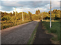
Hamilton Drive, Blantyre
Before the road was built the Hamilton to Strathaven railway line was here, see https://maps.nls.uk/geo/explore/#zoom=17&lat=55.78228&lon=-4.10815&layers=168&b=1
The line closed completely in 1960.
Image: © wrobison
Taken: 28 May 2022
0.06 miles
2

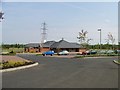
Hamilton International Technology Park
Image: © Iain Thompson
Taken: 27 Dec 2005
0.15 miles
4
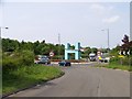
H is for Hamilton
This sign for the Hamilton International Technology Park greets you as you come down the slip road off the A725 "East Kilbride Expressway"
Image: © Elliott Simpson
Taken: 22 May 2008
0.16 miles