IMAGES TAKEN NEAR TO
Auchinraith Terrace, GLASGOW, G72 0LT
Introduction
This page details the photographs taken nearby to Auchinraith Terrace, G72 0LT by members of the Geograph project.
The Geograph project started in 2005 with the aim of publishing, organising and preserving representative images for every square kilometre of Great Britain, Ireland and the Isle of Man.

There are currently over 7.5m images from over14,400 individuals and you can help contribute to the project by visiting https://www.geograph.org.uk
Image Map
Images are licensed for reuse under creativecommons.org/licenses/by-sa/2.0
Notes
- Clicking on the map will re-center to the selected point.
- The higher the marker number, the further away the image location is from the centre of the postcode.
Image Listing (10 Images Found)
Images are licensed for reuse under creativecommons.org/licenses/by-sa/2.0
Image
Details
Distance
1
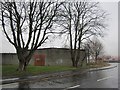
Building and barbed wire
Light industrial area, Auchinraith Road.
Image: © Richard Webb
Taken: 16 Mar 2013
0.08 miles
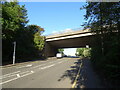
3
Slip road to A725
From A724 Glasgow Road
Image: © Jim Smillie
Taken: 14 Jun 2022
0.14 miles
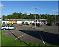
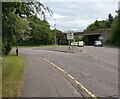
7

Whistleberry Retail Park
In Blantyre.
Image: © Stephen Sweeney
Taken: 17 Apr 2012
0.22 miles
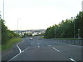
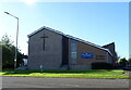
9
Cycle path at Ballantrae Road, Blantyre
Across open ground to Parkville Drive, the building on the left is the Springwell Community Centre.
Image: © wrobison
Taken: 7 Apr 2021
0.23 miles