IMAGES TAKEN NEAR TO
Uddingston Road, GLASGOW, G71 8TD
Introduction
This page details the photographs taken nearby to Uddingston Road, G71 8TD by members of the Geograph project.
The Geograph project started in 2005 with the aim of publishing, organising and preserving representative images for every square kilometre of Great Britain, Ireland and the Isle of Man.

There are currently over 7.5m images from over14,400 individuals and you can help contribute to the project by visiting https://www.geograph.org.uk
Image Map
Images are licensed for reuse under creativecommons.org/licenses/by-sa/2.0
Notes
- Clicking on the map will re-center to the selected point.
- The higher the marker number, the further away the image location is from the centre of the postcode.
Image Listing (4 Images Found)
Images are licensed for reuse under creativecommons.org/licenses/by-sa/2.0
Image
Details
Distance
1
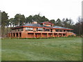
Bothwell Castle Golf Club - Clubhouse
Just off Bothwell Road, about half way between Bothwell and Uddingston.
Image: © G Laird
Taken: 13 Dec 2009
0.01 miles
2
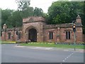
Entrance to Bothwell Castle Golf Club
A very grand entrance at that.
Image: © Stephen Sweeney
Taken: 16 Aug 2010
0.12 miles
3
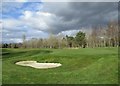
Bunker on deserted golf course, Bothwell
Usually this course would be a full of golfers on a bright Saturday afternoon, but like most amenities it is closed due to the Coronavirus Covid-19 outbreak.
Lots of people were out walking (like me) or cycling, however; trying to stay two metres apart from others as recommended to help prevent the spread of the virus.
Image: © Alan O'Dowd
Taken: 28 Mar 2020
0.18 miles
4
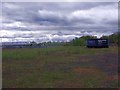
Uddingston, derelict land
This used to be the site of the Uddingston gas works, quite substantial it had its own railway spur.
Image: © Robert Murray
Taken: 4 May 2012
0.20 miles