IMAGES TAKEN NEAR TO
Knights Gate, GLASGOW, G71 8SS
Introduction
This page details the photographs taken nearby to Knights Gate, G71 8SS by members of the Geograph project.
The Geograph project started in 2005 with the aim of publishing, organising and preserving representative images for every square kilometre of Great Britain, Ireland and the Isle of Man.

There are currently over 7.5m images from over14,400 individuals and you can help contribute to the project by visiting https://www.geograph.org.uk
Image Map
Images are licensed for reuse under creativecommons.org/licenses/by-sa/2.0
Notes
- Clicking on the map will re-center to the selected point.
- The higher the marker number, the further away the image location is from the centre of the postcode.
Image Listing (6 Images Found)
Images are licensed for reuse under creativecommons.org/licenses/by-sa/2.0
Image
Details
Distance
1
Emerging from the woods by the Clyde Walkway
Into a housing estate in Bothwell.
Image: © Stephen Sweeney
Taken: 16 Aug 2010
0.05 miles
2
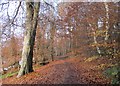
River Clyde Walkway north of Bothwell Castle
Woodland on the banks of the River Clyde in what was once part of the policies of Bothwell Castle.
Image: © Alan O'Dowd
Taken: 21 Nov 2019
0.12 miles
3
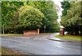
Castle Gate off Castle Avenue
Leading to one of several housing estates on the former grounds of Bothwell Castle
Image: © Jim Smillie
Taken: 7 Oct 2022
0.18 miles
4
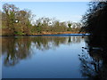
River Clyde near Uddingston
A river of contrasts here. Relatively tranquil in the foreground, but quite rapid in the distance after flowing over a very small waterfall.
Image: © G Laird
Taken: 31 Jan 2010
0.23 miles
5
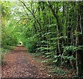
Track alongside golf course
This originally led towards Bothwell Castle
Image: © Jim Smillie
Taken: 7 Oct 2022
0.23 miles
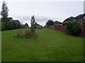
6
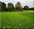
Green: Bothwell Castle Golf Club
The course had been closed earlier in the day due to heavy rain
Image: © Jim Smillie
Taken: 7 Oct 2022
0.24 miles