IMAGES TAKEN NEAR TO
Glebe Hollow, GLASGOW, G71 8QX
Introduction
This page details the photographs taken nearby to Glebe Hollow, G71 8QX by members of the Geograph project.
The Geograph project started in 2005 with the aim of publishing, organising and preserving representative images for every square kilometre of Great Britain, Ireland and the Isle of Man.

There are currently over 7.5m images from over14,400 individuals and you can help contribute to the project by visiting https://www.geograph.org.uk
Image Map
Images are licensed for reuse under creativecommons.org/licenses/by-sa/2.0
Notes
- Clicking on the map will re-center to the selected point.
- The higher the marker number, the further away the image location is from the centre of the postcode.
Image Listing (19 Images Found)
Images are licensed for reuse under creativecommons.org/licenses/by-sa/2.0
Image
Details
Distance
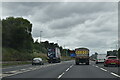
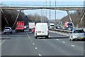
2
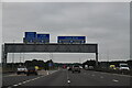
M74 north of Junction 5 (Raith Interchange)
Looking south towards the Raith Interchange, a notorious bottleneck at commuter time.
Image: © G Laird
Taken: 13 Dec 2009
0.18 miles
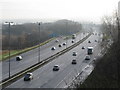
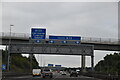
4
Looking south on the M74
From a bridge at Bothwell, just north of junction 5. Strathclyde Loch can be seen to the left of the centre of the image, and Tinto Hill is on the horizon.
Image: © Stephen Sweeney
Taken: 18 Jul 2011
0.19 miles
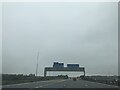
6
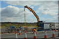
South Lanarkshire : The M74 Motorway
Roadworks taking place on the M74 at the Raith Interchange.
Image: © Lewis Clarke
Taken: 25 Apr 2016
0.20 miles
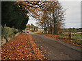
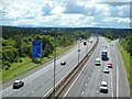
10
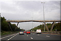
Bridge carrying a farm track over the M74 at Bothwell
Image: © Peter Bond
Taken: 30 Sep 2011
0.20 miles