IMAGES TAKEN NEAR TO
Blantyre Road, GLASGOW, G71 8PJ
Introduction
This page details the photographs taken nearby to Blantyre Road, G71 8PJ by members of the Geograph project.
The Geograph project started in 2005 with the aim of publishing, organising and preserving representative images for every square kilometre of Great Britain, Ireland and the Isle of Man.

There are currently over 7.5m images from over14,400 individuals and you can help contribute to the project by visiting https://www.geograph.org.uk
Image Map
Images are licensed for reuse under creativecommons.org/licenses/by-sa/2.0
Notes
- Clicking on the map will re-center to the selected point.
- The higher the marker number, the further away the image location is from the centre of the postcode.
Image Listing (13 Images Found)
Images are licensed for reuse under creativecommons.org/licenses/by-sa/2.0
Image
Details
Distance
1
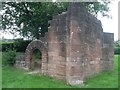
Ruin in Bothwell
I'm not sure exactly what it was, although it looks like it may have been a folly. Any info would be appreciated.
Image: © Stephen Sweeney
Taken: 16 Aug 2010
0.11 miles
2
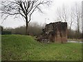
Ruin,Bothwell
A pile of stones, but no antiquity marked on the map. On the entrance to Barassie Court, a residential street.
Image: © Richard Webb
Taken: 16 Mar 2013
0.11 miles
3
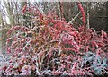
Frosted shrubbery
Frost persisted all day on the colourful leaves and berries.
Image: © Alan O'Dowd
Taken: 30 Nov 2019
0.12 miles
4
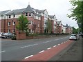
New flats in Bothwell
On Blantyre Road.
Image: © Stephen Sweeney
Taken: 16 Aug 2010
0.12 miles
5
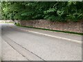
Blantyre Mill Road
Most likely the wall would be the original boundary of Bothwell Castle Park
Image: © Jim Smillie
Taken: 14 Jun 2022
0.13 miles
6
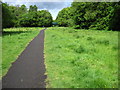
Nature trail on former railway at Bothwell
Image: © Chris Wimbush
Taken: 28 May 2010
0.14 miles
7
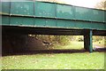
An old railway bridge in Bothwell.
Track bed of the railway is now a walkway.
Image: © Elliott Simpson
Taken: 28 Oct 2006
0.17 miles
8
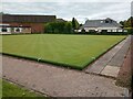
Bothwell Bowling Green
From Blantyre Mill Road; club address is Station Road
Image: © Jim Smillie
Taken: 14 Jun 2022
0.20 miles
9
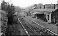
Bothwell (NBR) Station (remains)
View SSW, towards Hamilton; ex-NBR Glasgow Queen St. (Low Level) etc. via Shettleston - Hamilton line. The line on to Hamilton had already been closed on 15/9/52 and this station, which was just across the road from the Caledonian terminus, had been closed on 4/7/55 but was open for goods until 6/6/61 when the line from Shettleston was closed for good.
Image: © Ben Brooksbank
Taken: 6 Oct 1961
0.20 miles
10
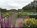
Bothwell Community Garden
The garden was established to provide a community focal point for, but not exclusively, those interested in gardening.
Image: © Roy Smart
Taken: 14 Aug 2016
0.21 miles