IMAGES TAKEN NEAR TO
Pailis Crescent, GLASGOW, G71 8FP
Introduction
This page details the photographs taken nearby to Pailis Crescent, G71 8FP by members of the Geograph project.
The Geograph project started in 2005 with the aim of publishing, organising and preserving representative images for every square kilometre of Great Britain, Ireland and the Isle of Man.

There are currently over 7.5m images from over14,400 individuals and you can help contribute to the project by visiting https://www.geograph.org.uk
Image Map
Images are licensed for reuse under creativecommons.org/licenses/by-sa/2.0
Notes
- Clicking on the map will re-center to the selected point.
- The higher the marker number, the further away the image location is from the centre of the postcode.
Image Listing (14 Images Found)
Images are licensed for reuse under creativecommons.org/licenses/by-sa/2.0
Image
Details
Distance
1
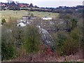
Sewage Works at Bothwell
Taken from the other side of the Clyde, on the Walkway. The substantial bridge (carrying sewage pipes?) is unmarked on the OS 50,000 mapping.
Image: © Gordon Brown
Taken: 12 Apr 2008
0.12 miles
2
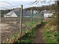
Right of Way from Clyde Avenue to Blantyre Mill Road, Bothwell
Now beside a new housing development. The Right of Way sign that used to be at the end of Clyde Avenue is now missing but it can still be seen in Street View https://goo.gl/maps/15tfay2AGd1F6FTH8
Image: © wrobison
Taken: 2 Apr 2021
0.14 miles
3
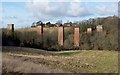
Remains of Craighead Viaduct
These brick piers are the remains of a railway bridge, which carried the Hamilton and Bothwell line of the North British Railway over the River Clyde. The bridge was built by Sir William Arrol of Dalmarnock. His company, Sir William Arrol & Co, would later built the Forth Rail Bridge.
The houses in the background are in Grieve Croft in Bothwell. The photograph was taken from a point near the Clyde Walkway, which I was following at the time.
[By the time this photo was submitted, the piers had already gone (they had been demolished about a year earlier), and the point from which the photo was taken was inside a construction site, but it had been in an open grassy area when the picture was taken.]
Image: © Lairich Rig
Taken: 17 Feb 2006
0.17 miles
4
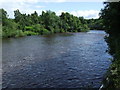
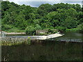
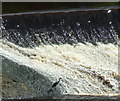
The River Clyde
Looking upstream from the weir at Blantyre.
Image: © Thomas Nugent
Taken: 19 Jul 2008
0.18 miles
5
The River Clyde
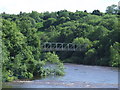
Above the weir at Blantyre. Viewed from the David Livingstone Memorial footbridge. The bridge amongst the trees carries a pipeline.
Image: © Thomas Nugent
Taken: 19 Jul 2008
0.19 miles
7
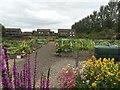
Bothwell Community Garden
The garden was established to provide a community focal point for, but not exclusively, those interested in gardening.
Image: © Roy Smart
Taken: 14 Aug 2016
0.22 miles
9
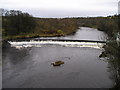
Weir on the River Clyde
Viewed from the David Livingstone Memorial footbridge. Can you see the heron?
Image: © Thomas Nugent
Taken: 19 Jul 2008
0.23 miles
10
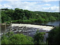
Weir on the River Clyde
Viewed from the David Livingstone Memorial footbridge.
Image: © Thomas Nugent
Taken: 19 Jul 2008
0.23 miles