IMAGES TAKEN NEAR TO
Killermont Meadows, GLASGOW, G71 8EG
Introduction
This page details the photographs taken nearby to Killermont Meadows, G71 8EG by members of the Geograph project.
The Geograph project started in 2005 with the aim of publishing, organising and preserving representative images for every square kilometre of Great Britain, Ireland and the Isle of Man.

There are currently over 7.5m images from over14,400 individuals and you can help contribute to the project by visiting https://www.geograph.org.uk
Image Map
Images are licensed for reuse under creativecommons.org/licenses/by-sa/2.0
Notes
- Clicking on the map will re-center to the selected point.
- The higher the marker number, the further away the image location is from the centre of the postcode.
Image Listing (8 Images Found)
Images are licensed for reuse under creativecommons.org/licenses/by-sa/2.0
Image
Details
Distance
1
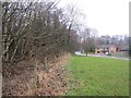
Castle Avenue
Newish houses on one side, old woods on the other.
Image: © Richard Webb
Taken: 16 Mar 2013
0.15 miles
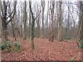
2
Woodland, Bothwell
An old wall on the edge of the woods which cover steep slopes above the Clyde.
Image: © Richard Webb
Taken: 16 Mar 2013
0.16 miles
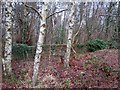
3
Woodland, Bothwell
Woods above the Clyde, south of Bothwell Castle.
Image: © Richard Webb
Taken: 16 Mar 2013
0.19 miles
4
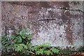
Clyde Walkway at Uddingston
a carving on the rock face says "Clyde rose to this mark March 12 1782"
Image: © Elliott Simpson
Taken: 28 Oct 2006
0.20 miles
5
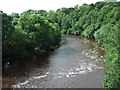
The River Clyde
View downstream from the David Livingstone Memorial footbridge.
Image: © Thomas Nugent
Taken: 19 Jul 2008
0.24 miles

7
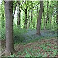
Bluebells by the Clyde Walkway, Bothwell
Plenty of bluebells were in bloom in these woods in the former policies of Bothwell Castle.
Image: © Alan O'Dowd
Taken: 9 May 2020
0.24 miles
