IMAGES TAKEN NEAR TO
Coalburn Road, GLASGOW, G71 8DA
Introduction
This page details the photographs taken nearby to Coalburn Road, G71 8DA by members of the Geograph project.
The Geograph project started in 2005 with the aim of publishing, organising and preserving representative images for every square kilometre of Great Britain, Ireland and the Isle of Man.

There are currently over 7.5m images from over14,400 individuals and you can help contribute to the project by visiting https://www.geograph.org.uk
Image Map
Images are licensed for reuse under creativecommons.org/licenses/by-sa/2.0
Notes
- Clicking on the map will re-center to the selected point.
- The higher the marker number, the further away the image location is from the centre of the postcode.
Image Listing (10 Images Found)
Images are licensed for reuse under creativecommons.org/licenses/by-sa/2.0
Image
Details
Distance
2
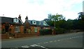
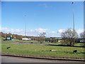
The road from Uddingston to Viewpark
Image: © Elliott Simpson
Taken: 23 Mar 2009
0.16 miles
3
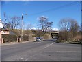
Track passing railway bridges
The nearer bridge carried the Hamilton Palace Colliery line.
The other bridge carries the electrified main line.
Image: © Jim Smillie
Taken: 20 Oct 2021
0.23 miles
5
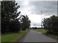
The service entrance to the Bothwell Services
Image: © Elliott Simpson
Taken: 23 Mar 2009
0.23 miles
7
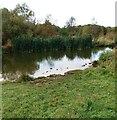
Pond in Old Mine Nature Park
As I passed behind earlier I could here dogs splashing about in the pond
Image: © Jim Smillie
Taken: 20 Oct 2021
0.24 miles
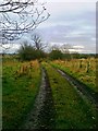
9
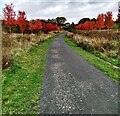
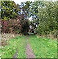
Old Mine Nature Park
Track lined with red maple trees
Image: © Jim Smillie
Taken: 20 Oct 2021
0.24 miles
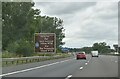
10
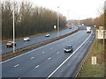
M74 near Uddingston
Looking along the M74 in the direction of Glasgow.
Image: © G Laird
Taken: 13 Dec 2009
0.25 miles