IMAGES TAKEN NEAR TO
Easter Hawhill Gate, GLASGOW, G71 7TX
Introduction
This page details the photographs taken nearby to Easter Hawhill Gate, G71 7TX by members of the Geograph project.
The Geograph project started in 2005 with the aim of publishing, organising and preserving representative images for every square kilometre of Great Britain, Ireland and the Isle of Man.

There are currently over 7.5m images from over14,400 individuals and you can help contribute to the project by visiting https://www.geograph.org.uk
Image Map
Images are licensed for reuse under creativecommons.org/licenses/by-sa/2.0
Notes
- Clicking on the map will re-center to the selected point.
- The higher the marker number, the further away the image location is from the centre of the postcode.
Image Listing (26 Images Found)
Images are licensed for reuse under creativecommons.org/licenses/by-sa/2.0
Image
Details
Distance
1
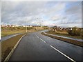
Baillieston, the new Serpent's Twist
Council name is Boghall road. Recently widened and resurfaced, the alignment has also been altered.
See Image for view from east and before housing development wrecked good farmland.
Image: © Robert Murray
Taken: 18 Feb 2012
0.03 miles
2
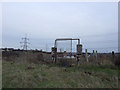
Mount Vernon Sports Stadium - Old Entrance Gate
Neglected Mount Vernon Sports Stadium, previously greyhound track.
Image: © emma mykytyn
Taken: 19 Jan 2008
0.06 miles
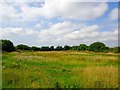
3
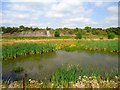
Serpent's Twist [3] The Little Moss
Ancient Sasine records name this place the Little Moss and after being drained for decades and used as prime agricultural land it has been allowed to return to its almost natural state.
Image: © Robert Murray
Taken: 25 Aug 2013
0.06 miles
4
The Avenues, Calderpark
New housing development north of Broomhouse.
Image: © Stephen Sweeney
Taken: 30 Apr 2009
0.08 miles
5
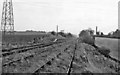
Broomhouse Station (remains)
View SE, towards Hamilton; ex-North British Glasgow (Queen St. LL) - Shettleston - Bothwell - Hamilton line. This station was closed to passengers back on 24/9/27 (goods on 1/9/53), but passenger trains continued to Bothwell until 4/7/55. However, traffic of some sort was evidently still passing in 1961.
Image: © Ben Brooksbank
Taken: 6 Oct 1961
0.09 miles
6
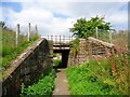
Baillieston, railway bridge
Triple track bridge built by the Caledonian Railway in 1863 as a double track it was widened in the 1870s to take a spur line into the nearby Daldowie Colliery. In this photo the removed span can be seen.
Image: © Robert Murray
Taken: 25 Aug 2013
0.09 miles
7
Derelict greyhound track
Built in the late 1930s after the pit (Daldowie Colliery) that stood here closed down, Mount Vernon Stadium closed down in the late 1980s.
Image: © Robert Murray
Taken: 25 Aug 2013
0.10 miles
8
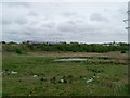
Water body by Daldowie Road
Does not appear on the OS map. Possibly flooded. Train bound for Glasgow Central in the background.
Image: © Stephen Sweeney
Taken: 30 Apr 2009
0.10 miles
9
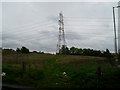
Pylons west of Broomhouse
From Daldowie Road.
Image: © Stephen Sweeney
Taken: 30 Apr 2009
0.10 miles
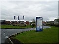
10
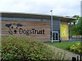
Dogs Trust, Glasgow
Located on Daldowie Road near Mount Vernon.
Image: © Stephen Sweeney
Taken: 30 Apr 2009
0.15 miles