IMAGES TAKEN NEAR TO
Greenoakhill Avenue, GLASGOW, G71 7RD
Introduction
This page details the photographs taken nearby to Greenoakhill Avenue, G71 7RD by members of the Geograph project.
The Geograph project started in 2005 with the aim of publishing, organising and preserving representative images for every square kilometre of Great Britain, Ireland and the Isle of Man.

There are currently over 7.5m images from over14,400 individuals and you can help contribute to the project by visiting https://www.geograph.org.uk
Image Map (Loading...)


Getting Data...Please wait
Leaflet Map data © OpenStreetMap
Images are licensed for reuse under creativecommons.org/licenses/by-sa/2.0
Notes
- Clicking on the map will re-center to the selected point.
- The higher the marker number, the further away the image location is from the centre of the postcode.
Image Listing (45 Images Found)
Images are licensed for reuse under creativecommons.org/licenses/by-sa/2.0
Image
Details
Distance
1
The Avenues, Calderpark
From Muirhead Road.
Image: © Stephen Sweeney
Taken: 30 Apr 2009
0.03 miles
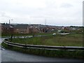
2
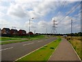
Lusshill, new housing
The original name of the area taken from the farm of the same name.
Image: © Robert Murray
Taken: 25 Aug 2013
0.04 miles
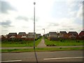
3
Calderbank Road, Broomhouse
There is a lot of housing development taking place or planned in this area. There is a show house on the left.
Image: © Richard Webb
Taken: 23 Apr 2012
0.08 miles
4
Baillieston, The Serpent's Twist
Looking towards the Hangman's Brae.
Image: © Robert Murray
Taken: 28 Jul 2007
0.08 miles
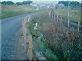
5
Serpent's Twist
Realignment of the burn. This seasonal burn ran alongside the southern side of the road but housing developments have had it moved to the north of the new road.
Image: © Robert Murray
Taken: 25 Aug 2013
0.09 miles
7
The Serpent's Twist
Officially designated 'Boghall Road' the land to the left of the road is now mainly built on. Photo taken from the 'Hangman's Brae'.
Image: © Robert Murray
Taken: 24 Jun 2004
0.09 miles
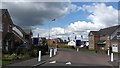
8
Baillieston Road
The end of Billieston Road at its junction with Boghall Road.
Image: © Malcolm Neal
Taken: 1 Jul 2021
0.10 miles
10
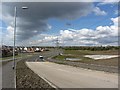
Boghall Road
A new road replaces a twisty rural road. The area is undergoing development for housing.
Image: © Richard Webb
Taken: 23 Apr 2012
0.12 miles