IMAGES TAKEN NEAR TO
Ferry Road, GLASGOW, G71 7QG
Introduction
This page details the photographs taken nearby to Ferry Road, G71 7QG by members of the Geograph project.
The Geograph project started in 2005 with the aim of publishing, organising and preserving representative images for every square kilometre of Great Britain, Ireland and the Isle of Man.

There are currently over 7.5m images from over14,400 individuals and you can help contribute to the project by visiting https://www.geograph.org.uk
Image Map
Images are licensed for reuse under creativecommons.org/licenses/by-sa/2.0
Notes
- Clicking on the map will re-center to the selected point.
- The higher the marker number, the further away the image location is from the centre of the postcode.
Image Listing (22 Images Found)
Images are licensed for reuse under creativecommons.org/licenses/by-sa/2.0
Image
Details
Distance
1
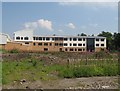
Uddingston Grammar School
The new building in the latter days of construction. It finally opened in January 2009. The location has proved controversial due to its riverside site.
Image: © Richard Webb
Taken: 25 Jul 2008
0.06 miles
2
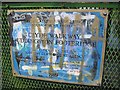
Plaque, Uddingston Footbridge
For once, the graffiti is (albeit unintentionally) almost artistic.
Image: © Richard Webb
Taken: 25 Jul 2008
0.17 miles
3
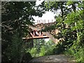
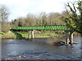
Railway bridge, Uddingston
West Coast main line crosses the Clyde by the red girder bridge - only the iron arches remain of the foreground bridge.
Image: © Richard Webb
Taken: 25 Jul 2008
0.17 miles
4
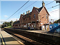
Uddingston railway station
The station was opened by the Clydesdale Junction Railway in 1849. It was renamed Uddingston Central Station by British Railways in March 1952, later reverting to Uddingston.
Image: © Thomas Nugent
Taken: 25 Sep 2015
0.18 miles
5
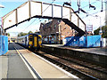
Uddingston railway station
Scotrail Class 156 train number 156 514 pulling away from Platform 2 which is used for south and east bound services.
Image: © Thomas Nugent
Taken: 25 Sep 2015
0.18 miles
6
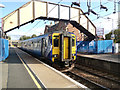
Uddingston railway station
Scotrail Class 156 train number 156 514 at Platform 2 which is used for south and east bound services.
Image: © Thomas Nugent
Taken: 25 Sep 2015
0.18 miles
7
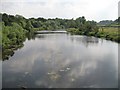
River Clyde
View upstream from the footbridge carrying the Clyde Walkway and National Cycle Route 1.
Image: © Richard Webb
Taken: 25 Jul 2008
0.18 miles
8
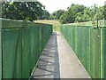
Uddingston footbridge
Built in 1989, the bridge carries the Clyde Walkway, and now National Cycle Route 75, over the river.
Image: © Richard Webb
Taken: 25 Jul 2008
0.18 miles
9
The Green Bridge leading to Uddingston
After crossing the Rotten Calder (river) and passing through the replanted woodlands on Brickworks Hill, the Clyde Walkway crosses the River Clyde by means of this lime green footbridge (about thirty metres to the north, a rail bridge also crosses the river). On the far side of the footbridge, walkers can choose either to keep heading east into Uddingston, or to turn southwards, following the River Clyde for about a mile to arrive at the impressive ruins of Bothwell Castle.
Image: © Lairich Rig
Taken: 8 Apr 2005
0.18 miles
10
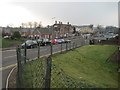
Uddingston railway station, Lanarkshire, 2014
Believed to have opened in 1878 (needs confirmation) by the Caledonian Railway on the line from Motherwell to Rutherglen and Glasgow, this station replaced an earlier 1849 one to the east of Glasgow Road bridge - see Image
View south west from an approach road, towards Newton and Glasgow. The 1962 footbridge seen here was replaced in 2024 with a new footbridge and lifts.
Image: © Nigel Thompson
Taken: 29 Mar 2014
0.19 miles