IMAGES TAKEN NEAR TO
James Weir Grove, GLASGOW, G71 7PL
Introduction
This page details the photographs taken nearby to James Weir Grove, G71 7PL by members of the Geograph project.
The Geograph project started in 2005 with the aim of publishing, organising and preserving representative images for every square kilometre of Great Britain, Ireland and the Isle of Man.

There are currently over 7.5m images from over14,400 individuals and you can help contribute to the project by visiting https://www.geograph.org.uk
Image Map
Images are licensed for reuse under creativecommons.org/licenses/by-sa/2.0
Notes
- Clicking on the map will re-center to the selected point.
- The higher the marker number, the further away the image location is from the centre of the postcode.
Image Listing (13 Images Found)
Images are licensed for reuse under creativecommons.org/licenses/by-sa/2.0
Image
Details
Distance
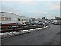
2
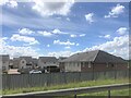
A development opportunity on Bellshill Road
The site of the former Sunvic Controls factory
Image: © Elliott Simpson
Taken: 5 Dec 2012
0.09 miles

4
South Lanarkshire : Tarmac
Tarmac a CRH Company based alongside the M74 motorway.
Image: © Lewis Clarke
Taken: 25 Apr 2016
0.14 miles
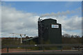
6
Green Elms Trading Estate, Uddingston
Image: © Stephen Sweeney
Taken: 15 Dec 2010
0.15 miles
7
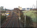
Main Railway Line to Glasgow
A section of the Glasgow to London railway line as it passes near to Uddingston. The line from Bellshill which joins the main line runs down the top of the embankment to the right.
Image: © G Laird
Taken: 13 Dec 2009
0.17 miles

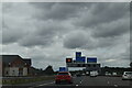
9
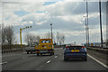
South Lanarkshire : The M74 Motorway
Heading along the M74 motorway.
Image: © Lewis Clarke
Taken: 25 Apr 2016
0.19 miles
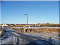
10
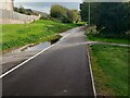
Cyclepath on old rail route
Large puddle on footpath side
Image: © Jim Smillie
Taken: 7 Oct 2022
0.19 miles