IMAGES TAKEN NEAR TO
Lynn Walk, GLASGOW, G71 7NR
Introduction
This page details the photographs taken nearby to Lynn Walk, G71 7NR by members of the Geograph project.
The Geograph project started in 2005 with the aim of publishing, organising and preserving representative images for every square kilometre of Great Britain, Ireland and the Isle of Man.

There are currently over 7.5m images from over14,400 individuals and you can help contribute to the project by visiting https://www.geograph.org.uk
Image Map
Images are licensed for reuse under creativecommons.org/licenses/by-sa/2.0
Notes
- Clicking on the map will re-center to the selected point.
- The higher the marker number, the further away the image location is from the centre of the postcode.
Image Listing (6 Images Found)
Images are licensed for reuse under creativecommons.org/licenses/by-sa/2.0
Image
Details
Distance
1
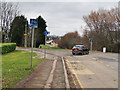
National Cycle Network Route 74 at Uddingston
Looking north where the Route crosses the Bellshill Road and continues to follow the line of an old railway. About 500m further on the Route joins Route 75.
Image: © wrobison
Taken: 9 Mar 2021
0.03 miles
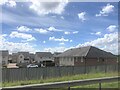
2
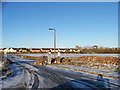
A development opportunity on Bellshill Road
The site of the former Sunvic Controls factory
Image: © Elliott Simpson
Taken: 5 Dec 2012
0.12 miles
3
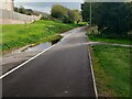
Cyclepath on old rail route
Large puddle on footpath side
Image: © Jim Smillie
Taken: 7 Oct 2022
0.12 miles
4
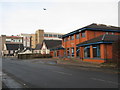
Uddingston Library
To the left of the library is the Freedom Church and in the background Tunnock's Bakery.
Image: © G Laird
Taken: 13 Dec 2009
0.20 miles
6
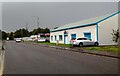
Hornal Road
Bothwellpark Industrial Estate
Image: © Jim Smillie
Taken: 7 Oct 2022
0.24 miles