IMAGES TAKEN NEAR TO
Brightside Avenue, GLASGOW, G71 7NF
Introduction
This page details the photographs taken nearby to Brightside Avenue, G71 7NF by members of the Geograph project.
The Geograph project started in 2005 with the aim of publishing, organising and preserving representative images for every square kilometre of Great Britain, Ireland and the Isle of Man.

There are currently over 7.5m images from over14,400 individuals and you can help contribute to the project by visiting https://www.geograph.org.uk
Image Map
Images are licensed for reuse under creativecommons.org/licenses/by-sa/2.0
Notes
- Clicking on the map will re-center to the selected point.
- The higher the marker number, the further away the image location is from the centre of the postcode.
Image Listing (21 Images Found)
Images are licensed for reuse under creativecommons.org/licenses/by-sa/2.0
Image
Details
Distance
1
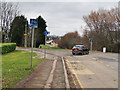
National Cycle Network Route 74 at Uddingston
Looking north where the Route crosses the Bellshill Road and continues to follow the line of an old railway. About 500m further on the Route joins Route 75.
Image: © wrobison
Taken: 9 Mar 2021
0.12 miles
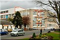
2
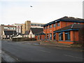
Uddingston Library
To the left of the library is the Freedom Church and in the background Tunnock's Bakery.
Image: © G Laird
Taken: 13 Dec 2009
0.12 miles
3
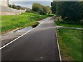
Cyclepath on old rail route
Large puddle on footpath side
Image: © Jim Smillie
Taken: 7 Oct 2022
0.17 miles
4
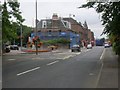
Uddingston Main Street at Old Glasgow Road
Image: © Stephen Sweeney
Taken: 16 Aug 2010
0.20 miles
5

Tunnock's Bakery
Among others, home of Tunnock's Caramel Wafers and Tunnock's Teacakes, both depicted on the front of the bakery.
Image: © G Laird
Taken: 13 Dec 2009
0.20 miles
6
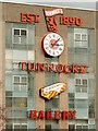
Tunnock's factory - front wall, with clockface
Image: © Lairich Rig
Taken: 1 Apr 2005
0.20 miles
7
Tunnock's factory
Tunnock's is a family firm based in Uddingston.
The factory is situated alongside Old Mill Road; its front wall is decorated with a large image of a caramel wafer, and a clockface which has an image of a teacake at its centre; these are shown in detail here: Image
The low building on the left is called "The Anvil Inn".
The photo was not taken with Geograph in mind; for a less cluttered view, see Image
[Despite the sign on the factory, the firm's own products are always labelled "Tunnock's", with the apostrophe, so I've used that spelling here.]
Image: © Lairich Rig
Taken: 1 Apr 2005
0.20 miles
8
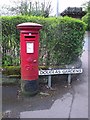
Uddingston, Douglas Gardens
With a George R pillarbox, presumably this was a George V (1910-1936) box without the letter.
Image: © Robert Murray
Taken: 4 May 2012
0.20 miles
9
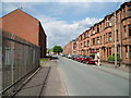
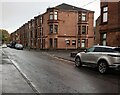
Crofthead Street
The tenement flats belong to West of Scotland Housing Association Ltd.
Image: © Gordon Dowie
Taken: 26 May 2010
0.21 miles
10
Tenements: Crofthead Street
Laighmuir Street on right
Image: © Jim Smillie
Taken: 7 Oct 2022
0.21 miles