IMAGES TAKEN NEAR TO
Kilgarth Drive, GLASGOW, G71 7GL
Introduction
This page details the photographs taken nearby to Kilgarth Drive, G71 7GL by members of the Geograph project.
The Geograph project started in 2005 with the aim of publishing, organising and preserving representative images for every square kilometre of Great Britain, Ireland and the Isle of Man.

There are currently over 7.5m images from over14,400 individuals and you can help contribute to the project by visiting https://www.geograph.org.uk
Image Map
Images are licensed for reuse under creativecommons.org/licenses/by-sa/2.0
Notes
- Clicking on the map will re-center to the selected point.
- The higher the marker number, the further away the image location is from the centre of the postcode.
Image Listing (16 Images Found)
Images are licensed for reuse under creativecommons.org/licenses/by-sa/2.0
Image
Details
Distance
1
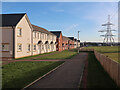
Pylon towering over the houses at Broomhouse
Image: © Eirian Evans
Taken: 27 Jun 2022
0.11 miles
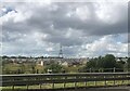
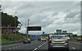
4
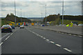
Glasgow City : The M73 Motorway
Heading southbound on the M73.
Image: © Lewis Clarke
Taken: 25 Apr 2016
0.17 miles
5
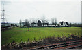
New houses at Ellismuir Park near Baillieston
Part of a large development on the lands of the old Ellismuir farm.
Image: © wrobison
Taken: 6 Mar 2022
0.18 miles
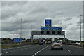
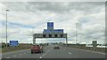
7
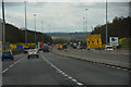
North Lanarkshire : The M73 Motorway
Heading south on the M73 motorway.
Image: © Lewis Clarke
Taken: 25 Apr 2016
0.18 miles
10
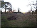
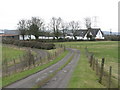
Baillieston, Calderbank House
The site of the old mansionhouse after its demolition in April 2002 - the result of a mysterious fire.
Image: © Robert Murray
Taken: 1 May 2006
0.22 miles