IMAGES TAKEN NEAR TO
Myers Court, GLASGOW, G71 7FL
Introduction
This page details the photographs taken nearby to Myers Court, G71 7FL by members of the Geograph project.
The Geograph project started in 2005 with the aim of publishing, organising and preserving representative images for every square kilometre of Great Britain, Ireland and the Isle of Man.

There are currently over 7.5m images from over14,400 individuals and you can help contribute to the project by visiting https://www.geograph.org.uk
Image Map
Images are licensed for reuse under creativecommons.org/licenses/by-sa/2.0
Notes
- Clicking on the map will re-center to the selected point.
- The higher the marker number, the further away the image location is from the centre of the postcode.
Image Listing (5 Images Found)
Images are licensed for reuse under creativecommons.org/licenses/by-sa/2.0
Image
Details
Distance
1
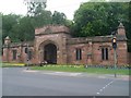
Entrance to Bothwell Castle Golf Club
A very grand entrance at that.
Image: © Stephen Sweeney
Taken: 16 Aug 2010
0.14 miles
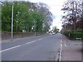
2

Hornal Road
Bothwellpark Industrial Estate
Image: © Jim Smillie
Taken: 7 Oct 2022
0.16 miles
3
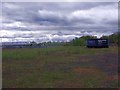
Uddingston, derelict land
This used to be the site of the Uddingston gas works, quite substantial it had its own railway spur.
Image: © Robert Murray
Taken: 4 May 2012
0.17 miles
4
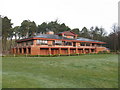
Bothwell Castle Golf Club - Clubhouse
Just off Bothwell Road, about half way between Bothwell and Uddingston.
Image: © G Laird
Taken: 13 Dec 2009
0.19 miles