IMAGES TAKEN NEAR TO
Rosefield Gardens, GLASGOW, G71 7AW
Introduction
This page details the photographs taken nearby to Rosefield Gardens, G71 7AW by members of the Geograph project.
The Geograph project started in 2005 with the aim of publishing, organising and preserving representative images for every square kilometre of Great Britain, Ireland and the Isle of Man.

There are currently over 7.5m images from over14,400 individuals and you can help contribute to the project by visiting https://www.geograph.org.uk
Image Map
Images are licensed for reuse under creativecommons.org/licenses/by-sa/2.0
Notes
- Clicking on the map will re-center to the selected point.
- The higher the marker number, the further away the image location is from the centre of the postcode.
Image Listing (24 Images Found)
Images are licensed for reuse under creativecommons.org/licenses/by-sa/2.0
Image
Details
Distance
1
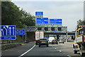
A74(M) motorway northbound
At the junction with the M73
Image: © Andrew Abbott
Taken: 14 Aug 2020
0.11 miles
2
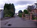
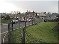
Uddingston, Holmwood Avenue
Some menacing firs need hacked here.
Image: © Robert Murray
Taken: 4 May 2012
0.12 miles
3
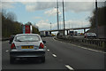
North Lanarkshire : The M74 Motorway
Heading along the M74 motorway.
Image: © Lewis Clarke
Taken: 25 Apr 2016
0.13 miles
4
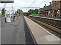
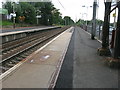
Uddingston railway station, looking East
View from platform 2 at Uddingston railway station, looking roughly East towards Motherwell, Lanark and Edinburgh via Shotts.
Image: © Andrew Reid
Taken: 8 Sep 2011
0.15 miles
5
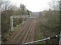
Uddingston railway station, looking West
View from platform 2 at Uddingston railway station, looking roughly West towards Glasgow.
Image: © Andrew Reid
Taken: 8 Sep 2011
0.15 miles
6
Uddingston railway station, Lanarkshire, 2014
Believed to have opened in 1878 (needs confirmation) by the Caledonian Railway on the line from Motherwell to Rutherglen and Glasgow, this station replaced an earlier 1849 one to the east of Glasgow Road bridge - see Image
View south west from an approach road, towards Newton and Glasgow. The 1962 footbridge seen here was replaced in 2024 with a new footbridge and lifts.
Image: © Nigel Thompson
Taken: 29 Mar 2014
0.15 miles

8
Uddingston 1st railway station (site), Lanarkshire
Opened in 1849 by the Clydesdale Junction Railway, later part of the Caledonian Railway, on the line from Motherwell to Rutherglen and Glasgow, this station was replaced by the current one, believed to be in 1878. For many years, the 1849 station was used as a goods station but was subsequently demolished. No trace apparently remains.
View east from Glasgow Road towards Motherwell, also Bellshill. The current station is behind the camera position.
Image: © Nigel Thompson
Taken: 29 Mar 2014
0.15 miles
9
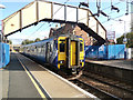
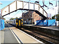
Uddingston railway station
Scotrail Class 156 train number 156 514 at Platform 2 which is used for south and east bound services.
Image: © Thomas Nugent
Taken: 25 Sep 2015
0.15 miles
10
Uddingston railway station
Scotrail Class 156 train number 156 514 pulling away from Platform 2 which is used for south and east bound services.
Image: © Thomas Nugent
Taken: 25 Sep 2015
0.15 miles