IMAGES TAKEN NEAR TO
Union Way, GLASGOW, G71 6UL
Introduction
This page details the photographs taken nearby to Union Way, G71 6UL by members of the Geograph project.
The Geograph project started in 2005 with the aim of publishing, organising and preserving representative images for every square kilometre of Great Britain, Ireland and the Isle of Man.

There are currently over 7.5m images from over14,400 individuals and you can help contribute to the project by visiting https://www.geograph.org.uk
Image Map
Images are licensed for reuse under creativecommons.org/licenses/by-sa/2.0
Notes
- Clicking on the map will re-center to the selected point.
- The higher the marker number, the further away the image location is from the centre of the postcode.
Image Listing (5 Images Found)
Images are licensed for reuse under creativecommons.org/licenses/by-sa/2.0
Image
Details
Distance
2
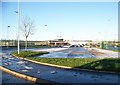
The car park at the new Tannochside Primary School
Image: © Elliott Simpson
Taken: 5 Dec 2012
0.12 miles
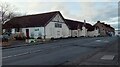
4
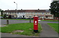
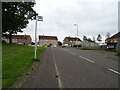
Houses on Burnhead Street
Showing position of Postbox No. G71 1199.
See Image] for postbox.
Image: © JThomas
Taken: 13 Sep 2021
0.24 miles
5
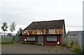
Tannochside & Bredisholm Miners' Welfare
On Old Edinburgh Road
Image: © Jim Smillie
Taken: 3 Feb 2023
0.25 miles