IMAGES TAKEN NEAR TO
Donaldson Green, GLASGOW, G71 6UF
Introduction
This page details the photographs taken nearby to Donaldson Green, G71 6UF by members of the Geograph project.
The Geograph project started in 2005 with the aim of publishing, organising and preserving representative images for every square kilometre of Great Britain, Ireland and the Isle of Man.

There are currently over 7.5m images from over14,400 individuals and you can help contribute to the project by visiting https://www.geograph.org.uk
Image Map
Images are licensed for reuse under creativecommons.org/licenses/by-sa/2.0
Notes
- Clicking on the map will re-center to the selected point.
- The higher the marker number, the further away the image location is from the centre of the postcode.
Image Listing (9 Images Found)
Images are licensed for reuse under creativecommons.org/licenses/by-sa/2.0
Image
Details
Distance
1
The car park at the new Tannochside Primary School
Image: © Elliott Simpson
Taken: 5 Dec 2012
0.19 miles
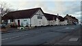
3
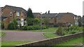
Barrwood Place
Newish houses, Tannochside.
Image: © Richard Webb
Taken: 25 Jul 2008
0.22 miles
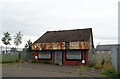
5
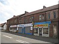
Shops, Old Edinburgh Road
Sandstone buildings on Old Edinburgh Road, Tannochside.
Image: © Richard Webb
Taken: 25 Jul 2008
0.23 miles
6
Tannochside & Bredisholm Miners' Welfare
On Old Edinburgh Road
Image: © Jim Smillie
Taken: 3 Feb 2023
0.23 miles
7
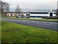
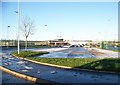
Tannochside Business Park
A modern Business Park offering office, workshop and warehouse accommodation.
Image: © Jim Smillie
Taken: 3 Feb 2023
0.23 miles
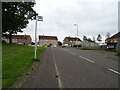
8
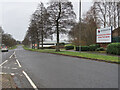
Tannochside Drive, Tannochside
The entrance road to the Tannochside Business Park which was established after the closure of the Caterpillar Tractor Co. in 1987.
Image: © wrobison
Taken: 22 Jan 2022
0.24 miles
9
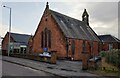
Viewpark Parish Church
With church cafe on left
Image: © Jim Smillie
Taken: 3 Feb 2023
0.24 miles