IMAGES TAKEN NEAR TO
New Edinburgh Road, GLASGOW, G71 6NF
Introduction
This page details the photographs taken nearby to New Edinburgh Road, G71 6NF by members of the Geograph project.
The Geograph project started in 2005 with the aim of publishing, organising and preserving representative images for every square kilometre of Great Britain, Ireland and the Isle of Man.

There are currently over 7.5m images from over14,400 individuals and you can help contribute to the project by visiting https://www.geograph.org.uk
Image Map
Images are licensed for reuse under creativecommons.org/licenses/by-sa/2.0
Notes
- Clicking on the map will re-center to the selected point.
- The higher the marker number, the further away the image location is from the centre of the postcode.
Image Listing (6 Images Found)
Images are licensed for reuse under creativecommons.org/licenses/by-sa/2.0
Image
Details
Distance

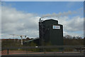
2

Cement works
The top of the cement works at Uddingston, seen above the lineside vegetation from a passing train on the West Coast Mainline.
Image: © Richard Sutcliffe
Taken: 9 May 2019
0.18 miles
3
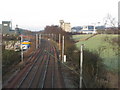
Main Railway Line to Glasgow
A section of the Glasgow to London railway line as it passes near to Uddingston. The line from Bellshill which joins the main line runs down the top of the embankment to the right.
Image: © G Laird
Taken: 13 Dec 2009
0.19 miles
4
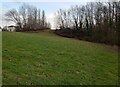
Open area off Spindlehowe Road
Shown on old map as a slag heap
Image: © Jim Smillie
Taken: 3 Feb 2023
0.21 miles
5
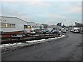
Green Elms Trading Estate, Uddingston
Image: © Stephen Sweeney
Taken: 15 Dec 2010
0.22 miles
6
South Lanarkshire : Tarmac
Tarmac a CRH Company based alongside the M74 motorway.
Image: © Lewis Clarke
Taken: 25 Apr 2016
0.24 miles