IMAGES TAKEN NEAR TO
Ashley Park, GLASGOW, G71 6LU
Introduction
This page details the photographs taken nearby to Ashley Park, G71 6LU by members of the Geograph project.
The Geograph project started in 2005 with the aim of publishing, organising and preserving representative images for every square kilometre of Great Britain, Ireland and the Isle of Man.

There are currently over 7.5m images from over14,400 individuals and you can help contribute to the project by visiting https://www.geograph.org.uk
Image Map
Images are licensed for reuse under creativecommons.org/licenses/by-sa/2.0
Notes
- Clicking on the map will re-center to the selected point.
- The higher the marker number, the further away the image location is from the centre of the postcode.
Image Listing (5 Images Found)
Images are licensed for reuse under creativecommons.org/licenses/by-sa/2.0
Image
Details
Distance
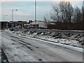
1
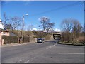
The road from Uddingston to Viewpark
Image: © Elliott Simpson
Taken: 23 Mar 2009
0.07 miles
2
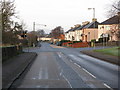
Crossroads on the A721 near Fallside
Looking along the A721 in the direction of Glasgow at the point where the B756 to Uddingston branches off to the left.
Image: © G Laird
Taken: 13 Dec 2009
0.07 miles
4
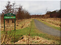
Old Mine Nature Park
An old industrial area between two railway lines. Bothwell Park Colliery Pits No.1&2 were at the eastern end of the site and Bothwell Park Quarry was at the western end. For an information leaflet download Old Mine Nature Park Leaflet.pdf from https://forestryandland.gov.scot/visit/old-mine-nature-park
Image: © wrobison
Taken: 9 Mar 2021
0.22 miles
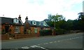
5
New Edinburgh Road, Fallside
From the bottom of Sanderson Avenue, looking east.
Image: © Stephen Sweeney
Taken: 15 Dec 2010
0.24 miles