IMAGES TAKEN NEAR TO
New Edinburgh Road, GLASGOW, G71 6LH
Introduction
This page details the photographs taken nearby to New Edinburgh Road, G71 6LH by members of the Geograph project.
The Geograph project started in 2005 with the aim of publishing, organising and preserving representative images for every square kilometre of Great Britain, Ireland and the Isle of Man.

There are currently over 7.5m images from over14,400 individuals and you can help contribute to the project by visiting https://www.geograph.org.uk
Image Map
Images are licensed for reuse under creativecommons.org/licenses/by-sa/2.0
Notes
- Clicking on the map will re-center to the selected point.
- The higher the marker number, the further away the image location is from the centre of the postcode.
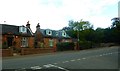
Image Listing (5 Images Found)
Images are licensed for reuse under creativecommons.org/licenses/by-sa/2.0
Image
Details
Distance
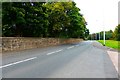
3
The road from Uddingston to Viewpark
Image: © Elliott Simpson
Taken: 23 Mar 2009
0.18 miles
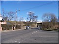
4
Crossroads on the A721 near Fallside
Looking along the A721 in the direction of Glasgow at the point where the B756 to Uddingston branches off to the left.
Image: © G Laird
Taken: 13 Dec 2009
0.18 miles
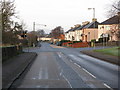
5
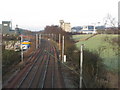
Main Railway Line to Glasgow
A section of the Glasgow to London railway line as it passes near to Uddingston. The line from Bellshill which joins the main line runs down the top of the embankment to the right.
Image: © G Laird
Taken: 13 Dec 2009
0.23 miles