IMAGES TAKEN NEAR TO
Ardenlea, GLASGOW, G71 6AG
Introduction
This page details the photographs taken nearby to Ardenlea, G71 6AG by members of the Geograph project.
The Geograph project started in 2005 with the aim of publishing, organising and preserving representative images for every square kilometre of Great Britain, Ireland and the Isle of Man.

There are currently over 7.5m images from over14,400 individuals and you can help contribute to the project by visiting https://www.geograph.org.uk
Image Map
Images are licensed for reuse under creativecommons.org/licenses/by-sa/2.0
Notes
- Clicking on the map will re-center to the selected point.
- The higher the marker number, the further away the image location is from the centre of the postcode.
Image Listing (13 Images Found)
Images are licensed for reuse under creativecommons.org/licenses/by-sa/2.0
Image
Details
Distance

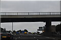
2
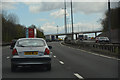
North Lanarkshire : The M74 Motorway
Heading along the M74 motorway.
Image: © Lewis Clarke
Taken: 25 Apr 2016
0.15 miles
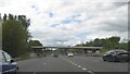
3
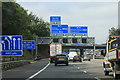
A74(M) motorway northbound
At the junction with the M73
Image: © Andrew Abbott
Taken: 14 Aug 2020
0.15 miles
4

Old Mill Road
At junction with New Edinburgh Road
Image: © Jim Smillie
Taken: 7 Oct 2022
0.18 miles
5
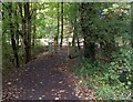
Woodland Walk Entrance
Thornwood Woods between New Edinburgh Road and the M74
Image: © Jim Smillie
Taken: 7 Oct 2022
0.19 miles
6
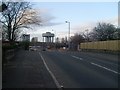
Heading north on Holmbrae Road
Nearing the roundabout at Old Edinburgh Road. Looking to the Tannochside water tower.
Image: © Stephen Sweeney
Taken: 19 Apr 2010
0.19 miles
8
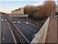
M74 motorway at Uddingston
Viewed from the old A74, now the B7071.
Image: © wrobison
Taken: 6 Mar 2022
0.22 miles
10
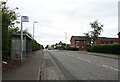
Bus stop and shelter on Old Edinburgh Road (B7001)
Image: © JThomas
Taken: 13 Sep 2021
0.23 miles