IMAGES TAKEN NEAR TO
Uddingston, GLASGOW, G71 5PL
Introduction
This page details the photographs taken nearby to G71 5PL by members of the Geograph project.
The Geograph project started in 2005 with the aim of publishing, organising and preserving representative images for every square kilometre of Great Britain, Ireland and the Isle of Man.

There are currently over 7.5m images from over14,400 individuals and you can help contribute to the project by visiting https://www.geograph.org.uk
Image Map
Images are licensed for reuse under creativecommons.org/licenses/by-sa/2.0
Notes
- Clicking on the map will re-center to the selected point.
- The higher the marker number, the further away the image location is from the centre of the postcode.
Image Listing (6 Images Found)
Images are licensed for reuse under creativecommons.org/licenses/by-sa/2.0
Image
Details
Distance
1
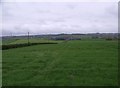
Great Newlands, pasture
Lush dairy pasture.
Image: © Robert Murray
Taken: 10 May 2012
0.05 miles
2
Great Newlands and Little Newlands
This dairy farm appears on Timothy Pont's map of 1591. http://maps.nls.uk/pont/index.html
Image: © Robert Murray
Taken: 10 May 2012
0.05 miles
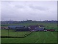
3
Farmland at Newlands Farm
Old map shows a pit and miners' rows near trees on right
Image: © Jim Smillie
Taken: 3 Feb 2023
0.09 miles
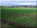
4
Great Newlands, old colliery site
The Bredisholm No.1 pit, abandoned in March 1933, part of the catastrophic closures which took place in the district in that year. Almost fifty families lived here too. the land has been well reclaimed.
Image: © Robert Murray
Taken: 10 May 2012
0.13 miles
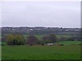
5
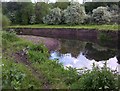
Pebble beach at Newlands Glen
The North Calder Water as it meanders through Bredisholm and it is not really a glen here more a kind of valley. The name comes from one Ossie Kneland who was a feur of the nearby Newlands Farm.
Image: © Robert Murray
Taken: 20 Sep 2009
0.21 miles
6
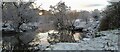
North Calder
Bargeddie side of the river not far from the M73 and Baillieston
Image: © Punkarama
Taken: 2 Feb 2021
0.23 miles