IMAGES TAKEN NEAR TO
Alder Bank, GLASGOW, G71 5NN
Introduction
This page details the photographs taken nearby to Alder Bank, G71 5NN by members of the Geograph project.
The Geograph project started in 2005 with the aim of publishing, organising and preserving representative images for every square kilometre of Great Britain, Ireland and the Isle of Man.

There are currently over 7.5m images from over14,400 individuals and you can help contribute to the project by visiting https://www.geograph.org.uk
Image Map
Images are licensed for reuse under creativecommons.org/licenses/by-sa/2.0
Notes
- Clicking on the map will re-center to the selected point.
- The higher the marker number, the further away the image location is from the centre of the postcode.
Image Listing (6 Images Found)
Images are licensed for reuse under creativecommons.org/licenses/by-sa/2.0
Image
Details
Distance
1
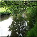
Still Waters
North Calder passing Crowflat Wood
Image: © Jim Smillie
Taken: 26 May 2022
0.18 miles
2
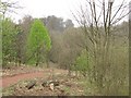
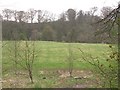
Viewpark Glen
Former policy woodland of Tannochside House.
Image: © Richard Webb
Taken: 23 Apr 2010
0.21 miles
3
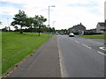
Laburnum Road, Viewpark
At the northern end of Viewpark.
Image: © G Laird
Taken: 25 Jul 2011
0.24 miles
5
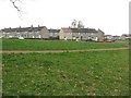
Viewpark Glen
Football pitch on low ground within a bend of the North Calder Water.
Image: © Richard Webb
Taken: 23 Apr 2010
0.25 miles
6
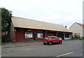
Viewpark
Banyan Crescent. Viewpark was built on the grounds of Tannochfield House, now demolished, in the 1950s.
Image: © Richard Webb
Taken: 23 Apr 2010
0.25 miles