IMAGES TAKEN NEAR TO
Laburnum Road, GLASGOW, G71 5DA
Introduction
This page details the photographs taken nearby to Laburnum Road, G71 5DA by members of the Geograph project.
The Geograph project started in 2005 with the aim of publishing, organising and preserving representative images for every square kilometre of Great Britain, Ireland and the Isle of Man.

There are currently over 7.5m images from over14,400 individuals and you can help contribute to the project by visiting https://www.geograph.org.uk
Image Map
Images are licensed for reuse under creativecommons.org/licenses/by-sa/2.0
Notes
- Clicking on the map will re-center to the selected point.
- The higher the marker number, the further away the image location is from the centre of the postcode.
Image Listing (15 Images Found)
Images are licensed for reuse under creativecommons.org/licenses/by-sa/2.0
Image
Details
Distance
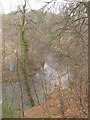
1
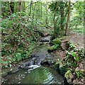
Red Burn: Viewpark Glen
Just before it flows into the North Calder
Image: © Jim Smillie
Taken: 26 May 2022
0.06 miles
2
Entering Viewpark Glen from Viewpark
The home-grown sign on approach to the glen by North Calder Water.
Image: © Stephen Sweeney
Taken: 15 Dec 2010
0.08 miles
3
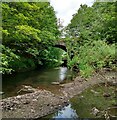
North Calder Water
At point where Red Burn joins.
Bridge is on edge of neighbouring square.
Image: © Jim Smillie
Taken: 26 May 2022
0.10 miles
4
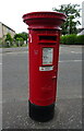
Postbox on Laburnum Road
Postbox No. G71 1286.
Image: © JThomas
Taken: 13 Sep 2021
0.11 miles
5
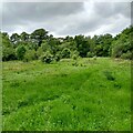
Douglas Support (Rosehall) Estate
Previously described as 'a well-established and extensive area of policy woodland and parkland'
Image: © Jim Smillie
Taken: 26 May 2022
0.14 miles
6
North Calder Water
View from Viewpark.
Image: © Richard Webb
Taken: 23 Apr 2010
0.15 miles
7
Former gateposts
Possibly the entrance to a former estate? In Viewpark Glen.
Image: © Stephen Sweeney
Taken: 15 Dec 2010
0.15 miles
8
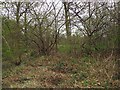
Woodland, Viewpark
Once this, and the adjacent Strathclyde Business Park was part of the policies of a large house, Tannochside House, which was demolished in the early 1950s to make way for the Viewpark housing scheme.
Image: © Richard Webb
Taken: 23 Apr 2010
0.15 miles
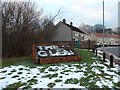
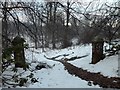
9
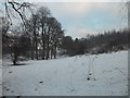
Snowy hillside by the North Calder Water
Near Viewpark.
Image: © Stephen Sweeney
Taken: 15 Dec 2010
0.18 miles
10
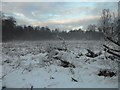
Foggy field NE of Viewpark
By the North Calder Water.
Image: © Stephen Sweeney
Taken: 15 Dec 2010
0.18 miles