IMAGES TAKEN NEAR TO
Woodhead Road, GLASGOW, G69 9JE
Introduction
This page details the photographs taken nearby to Woodhead Road, G69 9JE by members of the Geograph project.
The Geograph project started in 2005 with the aim of publishing, organising and preserving representative images for every square kilometre of Great Britain, Ireland and the Isle of Man.

There are currently over 7.5m images from over14,400 individuals and you can help contribute to the project by visiting https://www.geograph.org.uk
Image Map
Images are licensed for reuse under creativecommons.org/licenses/by-sa/2.0
Notes
- Clicking on the map will re-center to the selected point.
- The higher the marker number, the further away the image location is from the centre of the postcode.
Image Listing (5 Images Found)
Images are licensed for reuse under creativecommons.org/licenses/by-sa/2.0
Image
Details
Distance
1
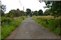
Garnkirk, railway bridge
Crosses the historically important Glasgow to Garnkirk Railway which opened in 1831. The famous George Stephenson in attendance.
Image: © Robert Murray
Taken: 3 Oct 2015
0.08 miles
2
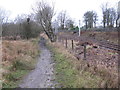
Path and Railway
The path leads to Stepps from Garnkirk.
The railway is a stretch of the Cumbernauld line between Stepps and Gartcosh railway stations.
Image: © G Laird
Taken: 1 Jan 2014
0.12 miles
3
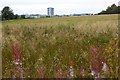
Garnkirk, overgrown field
The former Head Office of (the tower) of Buchanan's Whisky in the distance.
Image: © Robert Murray
Taken: 3 Oct 2015
0.12 miles
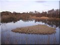
5
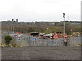
Woodhead Industrial Estate
At the end of Woodhead Road.
Image: © Richard Webb
Taken: 14 Oct 2011
0.21 miles