IMAGES TAKEN NEAR TO
Burnbrae Road, GLASGOW, G69 9HR
Introduction
This page details the photographs taken nearby to Burnbrae Road, G69 9HR by members of the Geograph project.
The Geograph project started in 2005 with the aim of publishing, organising and preserving representative images for every square kilometre of Great Britain, Ireland and the Isle of Man.

There are currently over 7.5m images from over14,400 individuals and you can help contribute to the project by visiting https://www.geograph.org.uk
Image Map
Images are licensed for reuse under creativecommons.org/licenses/by-sa/2.0
Notes
- Clicking on the map will re-center to the selected point.
- The higher the marker number, the further away the image location is from the centre of the postcode.
Image Listing (10 Images Found)
Images are licensed for reuse under creativecommons.org/licenses/by-sa/2.0
Image
Details
Distance
1
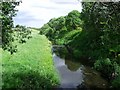
Bothlin Burn
The source of this burn is the Bishop Loch, it flows to the Luggie Water at Oxgangs east of Kirkintilloch.
Image: © Robert Murray
Taken: 12 Jun 2010
0.14 miles
3
Monklands and Kirkintilloch Railway
This is the remnants of a former railway called the Monkland and Kirkintilloch - One of Scotland's earliest railways it was authorised on 17 May 1824 and opened on 1 October 1826. Its main function was intended to be the transportation of coal from the Monklands coalfield around Old Monkland parish, but iron ore and passengers were also carried. The southern terminus was at Palacecraig on the Monkland Canal and the northern at Kirkintilloch basin on the Forth & Clyde. It was built to the Scotch gauge of 4 ft 6 in (1,372 mm).
Image: © Robert Murray
Taken: 12 Jun 2010
0.19 miles
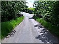
4

Narrow Bridge over the Bothlin Burn
The bridge carries Calfmuir Road across the Bothlin Burn north of Chryston.
Image: © G Laird
Taken: 1 Jan 2014
0.19 miles
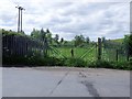
5
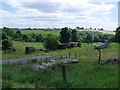
Wester Muckcroft
Steading or remains of.
Image: © Robert Murray
Taken: 12 Jun 2010
0.21 miles
6
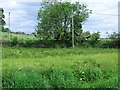
Causeway at Wester Muckcroft
Built to carry the road across a flood plain of the Bothlin Burn.
Image: © Robert Murray
Taken: 12 Jun 2010
0.21 miles
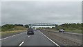
7
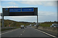
North Lanarkshire : The M80 Motorway
Heading along the M80 Motorway.
Image: © Lewis Clarke
Taken: 25 Apr 2016
0.23 miles
8
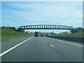
M80 about to pass under bridge with cycle path
Image: © Colin Pyle
Taken: 11 Jun 2015
0.24 miles
9
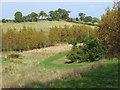
East Muckcroft Farm, near Kirkintilloch
Taken from an area of new amenity woodland - the first touch of autumn colours can be seen!
Image: © Brian D Osborne
Taken: 12 Sep 2005
0.24 miles