IMAGES TAKEN NEAR TO
Station Road, GLASGOW, G69 9HA
Introduction
This page details the photographs taken nearby to Station Road, G69 9HA by members of the Geograph project.
The Geograph project started in 2005 with the aim of publishing, organising and preserving representative images for every square kilometre of Great Britain, Ireland and the Isle of Man.

There are currently over 7.5m images from over14,400 individuals and you can help contribute to the project by visiting https://www.geograph.org.uk
Image Map
Images are licensed for reuse under creativecommons.org/licenses/by-sa/2.0
Notes
- Clicking on the map will re-center to the selected point.
- The higher the marker number, the further away the image location is from the centre of the postcode.
Image Listing (3 Images Found)
Images are licensed for reuse under creativecommons.org/licenses/by-sa/2.0
Image
Details
Distance
1
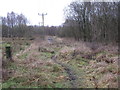
Track and Path Junction
Woodland south of Chryston.
Image: © G Laird
Taken: 1 Jan 2014
0.19 miles
2
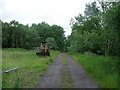
Track to Heathfield
And abandoned and rusting bulldozer.
Image: © Robert Murray
Taken: 12 Jun 2010
0.22 miles
3
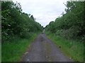
Station Road, Garnkirk
This now decrepit track is heavily polluted with oil and other nasty stuff which is running off into a pond in the woods to the left.
It used to be - as the title name implies the road to a railway station called Garnkirk. The line which is still in everyday use was one of Scotland's earliest railways called the Glasgow and Garnkirk Railway which opened to in 1831 as the first competitor to the monopoly until then enjoyed by the Monkland Canal in carrying coals and pig iron from the Monklands to Glasgow.
Image: © Robert Murray
Taken: 12 Jun 2010
0.25 miles