IMAGES TAKEN NEAR TO
Smethurst Drive, GLASGOW, G69 9FQ
Introduction
This page details the photographs taken nearby to Smethurst Drive, G69 9FQ by members of the Geograph project.
The Geograph project started in 2005 with the aim of publishing, organising and preserving representative images for every square kilometre of Great Britain, Ireland and the Isle of Man.

There are currently over 7.5m images from over14,400 individuals and you can help contribute to the project by visiting https://www.geograph.org.uk
Image Map
Images are licensed for reuse under creativecommons.org/licenses/by-sa/2.0
Notes
- Clicking on the map will re-center to the selected point.
- The higher the marker number, the further away the image location is from the centre of the postcode.
Image Listing (5 Images Found)
Images are licensed for reuse under creativecommons.org/licenses/by-sa/2.0
Image
Details
Distance
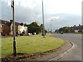
1
Building base and garages
Beside the Woodhead Road.
Image: © Richard Webb
Taken: 14 Oct 2011
0.17 miles
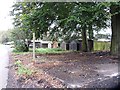
2
Station Road, Muirhead
Leads to the Garnkirk Railway.
Image: © Stephen Sweeney
Taken: 2 Aug 2011
0.17 miles
3
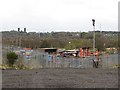
Woodhead Industrial Estate
At the end of Woodhead Road.
Image: © Richard Webb
Taken: 14 Oct 2011
0.19 miles
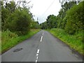
4
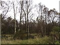
Heathfield Moss
A wooded bog off Station Road.
Image: © Richard Webb
Taken: 14 Oct 2011
0.21 miles