IMAGES TAKEN NEAR TO
Birkenshaw Road, GLASGOW, G69 8HL
Introduction
This page details the photographs taken nearby to Birkenshaw Road, G69 8HL by members of the Geograph project.
The Geograph project started in 2005 with the aim of publishing, organising and preserving representative images for every square kilometre of Great Britain, Ireland and the Isle of Man.

There are currently over 7.5m images from over14,400 individuals and you can help contribute to the project by visiting https://www.geograph.org.uk
Image Map
Images are licensed for reuse under creativecommons.org/licenses/by-sa/2.0
Notes
- Clicking on the map will re-center to the selected point.
- The higher the marker number, the further away the image location is from the centre of the postcode.
Image Listing (7 Images Found)
Images are licensed for reuse under creativecommons.org/licenses/by-sa/2.0
Image
Details
Distance
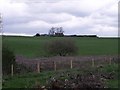
3
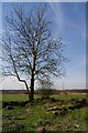
Looking through the trees to Leckethill
From Birkenshaw Road.
Image: © Stephen Sweeney
Taken: 10 Jan 2012
0.01 miles
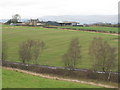
5
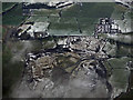
Leckethill tip from the air
The disused tip, with Annathill beyond.
Image: © Thomas Nugent
Taken: 24 Feb 2017
0.09 miles
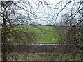
6
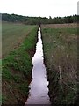
Long straight drain, Marnoch
Heavily polluted with ochre from old pit workings.
Image: © Robert Murray
Taken: 13 May 2010
0.23 miles
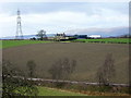
7
Birkenshaw Cottage (remains)
The remains of a two compartment cottage or farmstead.
Image: © Texas Radio and The Big Beat
Taken: 10 Apr 2010
0.24 miles